Andrushevka Zhytomyr. Andrushevka. The park also has a peninsula surrounded by an artificial water channel. Its abandoned remains remain
Villages and towns
Andrushevsky district
ANTOPL(Ukrainian Antopil) is the center of the Antopol village council, which does not include other settlements.
It is located 14 km west of the district center and 15 km from the Kodnya railway station.
Population: 490 people. (2001)
Story
The village has been known since 1880.
During World War II, 183 village residents fought against the Nazi invaders, of which 99 died a heroic death. In 1959, a monument was erected at the mass grave in honor of the fallen soldiers who liberated the village from the Nazi occupiers.
EYEBROWS FIRST(Ukrainian: Brovki Pershi) is the center of the Brovki village council, which also includes the village of Yareshki.
It is located 21 km southeast of the district center. Railroad station.
Population: 961 people (2001)
Story
The village has been known since 1617.
During the Second World War, 337 village residents fought against the Nazi invaders, of which 152 died a brave death for their Motherland. In 1962, in Brovki Pervy, a monument was erected at the mass grave of 19 soldiers-liberators of the village.
GREAT MOSHKOVTS(Ukrainian Velyky Moshkivtsi) is the center of the Velikomoshkovytsky village council, which does not include other settlements.
It is located 13 km west of the district center and 18 km from the Kodnya railway station.
Population: 534 people (2001)
Story
The village has been known since 1593.
During the Second World War, 423 village residents fought against the Nazi invaders, 130 died a brave death for their Motherland.
In 1960, a monument was erected at the mass grave of the soldiers who liberated the village from the Nazis.
WOLITSA(Ukrainian Volitsya) is the center of the Volitsya village council, which does not include other settlements.
It is located on the left bank of the Ivyanka River (a tributary of Teterev), 9 km northeast of the regional center and 7 km from the Stepok railway station. The Zhitomir - Skvira highway passes through the village.
Population: 805 people (2001)
Story
The village was first mentioned in 1605.
232 village residents took part in the fight against the Nazi invaders during the Second World War, of which 113 gave their lives for the freedom and independence of the Country. In 1956 a monument was erected, and in 1965 - an obelisk of Glory to the soldiers who died for the liberation of the village from the Nazi occupiers.
HAIR(Ukrainian Volosiv) is the center of the Volosovsky village council, which also includes the village of Chubarevka.
Located on the banks of the Guiva River, 25 km southwest of the district center and 4 km from the Grad railway station.
Population: 495 people (2001)
Story
The village has been known since 1609.
During the Second World War, 225 village residents fought against the Nazi invaders, 160 died in battle. In 1959, a monument was erected at the mass grave of 111 soldiers who liberated the village.
GALCHIN(Ukrainian Galchin) is the center of the Galchinsky village council, which does not include other settlements.
It is located on the left bank of the Guiva River, at the confluence of the Pustokha River, adjacent to the southern outskirts of the regional center, 23 km from the Brovki railway station.
Population: 2316 people. (2001)
Story
The village has been known since 1683.
During the Second World War, 420 village residents took part in the fight against the Nazi invaders, 162 died in battle. In 1958, a monument was erected at the mass grave of the soldiers who liberated the village.
GLINOVTSY(Ukrainian: Glinivtsi) is the center of the Glinivtsi village council, which does not include other settlements.
It is located 24 km west of the district center and 14 km from the Kodnya railway station.
Population: 648 people. (2001)
Story
The village has been known since 1735.
During the Second World War, 240 village residents took part in the battles against the Nazi invaders, 128 died a heroic death. In 1956, a monument was erected at the mass grave of the soldiers who liberated the village.
GORODKOVKA(Ukrainian: Gorodkivka) is the center of the Gorodkovsky village council, which does not include other settlements.
It is located on the right bank of the Guiva River (a tributary of Teterev), 15 km south of the regional center and 8 km from the Chernorudka railway station.
Population: 1095 people (2001)
Story
The village has been known since 1724.
During the Second World War, 480 village residents took part in battles with the Nazi invaders, 178 died a heroic death. In 1961, a monument was erected at the mass grave of 13 soldiers who liberated the village.
ZABARA(Ukrainian Zabara) is the center of the Zabarovsky village council, which also includes the village of Kotovka.
It is located 9 km southwest of the district center and 30 km from the Brovki railway station.
Population: 402 people (2001)
Story
The village has been known since 1683.
62 residents of the village took part in the battles against the Nazi occupiers, 26 died a brave death for their Motherland. In 1954, a monument was erected at the mass grave of the soldiers who liberated the village.
ZARUBINS(Ukrainian Zarubintsi) is the center of the Zarubintsy village council, which also includes the villages of Lesovka and Tarasovka.
It is located 9 km northeast of the district center and 12 km from the Yaropovichi railway station.
Population: 904 people (2001)
Story
The village has been known since 1602.
During the Second World War, 320 village residents fought against the Nazi invaders, of which 117 died in battle. A monument was erected at the mass grave of 18 soldiers who died for the liberation of the village in 1951.
IVANKOV(Ukrainian Ivankiv) - the center of the Ivankovsky village council, which, in addition, includes villages that do not include other settlements.
Located on the banks of the Guiva River (a tributary of Teterev), 25 km southwest of the regional center, 7 km from the Grad railway station and 2 km from the Zhitomir - Skvira highway.
Population: 809 people (2001)
Story
The village has been known since 1501.
During the Second World War, 280 village residents fought against the Nazi invaders.
In 1952-1960 In Ivankovo, monuments were erected at 5 mass graves of soldiers who liberated the village from the Nazi occupiers, and in 1970, a monument to 85 fellow villagers who died a brave death in battles for their Motherland.
IVNITSA(Ukrainian Ivnytsia) is the center of the Ivnytsia village council, which also includes the villages of Borok.
Located on the banks of the Ivyanka River (a tributary of Teterev), 23 km north of the regional center and 4 km from the Stepok railway station.
Population: 1644 people. (2001)
Story
The village has been known since 1584.
During the Second World War, 492 village residents fought the enemy, and 263 died a heroic death. In Ivnitsa in 1953, 1957, 1966, 4 monuments were erected on the mass graves of liberating soldiers, where 510 people were buried.
The village has a protected park from the second half of the 18th century.
STONES(Ukrainian Kamenі) is the center of the Kamenivsky village council, which also includes the villages of Brovki Vtorye and Zherdeli.
It is located on the left bank of the Guiva River (a tributary of Teterev), 20 km southwest of the regional center and 10 km from the Chernorudka railway station.
Population: 243 people (2001)
Story
During the Second World War, 129 village residents fought against the Nazi invaders, 68 died a heroic death.
KRYLOVKA(Ukrainian Krylivka) is the center of the Krylov village council, which does not include other settlements.
It is located on the right bank of the Pustokha River (a tributary of Guiva), 13 km southeast of the regional center and 16 km from the Chernorudka railway station.
Population: 962 people (2001)
Story
The first mention of the village dates back to 1616.
During the Second World War, 270 village residents fought against the Nazi invaders, 90 died in battles with the enemy.
In 1952, 1954 and 1964, three monuments were built on the mass graves of soldiers who died a brave death for the liberation of the village from the Nazi occupiers.
SWANS(Ukrainian Lebedyntsi) is the center of the Lebedynets village council, which does not include other settlements.
It is located 14 km southeast of the district center and 9 km from the Brovki railway station.
Population: 436 people. (2001)
Story
The village has been known since 1683.
290 village residents took part in the fight against the Nazi invaders, of which 140 died a heroic death. In 1956 and 1959, two monuments were erected at the mass graves of the liberating soldiers of Lebedintsy.
LYUBIMOVKA(Ukrainian Lyubimivka) is the center of the Lyubimovsky village council, which does not include other settlements.
It is located 18 km east of the regional center, 22 km from the Popelnya railway station and 2 km from the Zhitomir - Skvira highway.
Population: 500 people (2001)
Story
The village has been known since the 18th century.
During World War II, 302 residents of the village took part in the fight against the Nazi invaders, 148 died a brave death for their Motherland.
In 1958, a monument was erected at the mass grave of the liberating soldiers of Lyubimovka.
SMALL PYATIGORKA(Ukrainian Mala Pyatigirka) is the center of the Malopyatigorsk village council, which does not include other settlements.
It is located on the right bank of the Guiva River (a tributary of Teterev), 24 km southwest of the regional center and 9 km from the Chernorudka railway station.
Population: 396 people. (2001)
Story
The village has been known since 1864.
During the Second World War, 127 village residents fought against the Nazi invaders, of which 63 died in battle. A monument was erected at the mass grave of the soldiers-liberators of the village in 1956.
SMALL MOSHKOVTSY(Ukrainian: Mali Moshkivtsi) is the center of the Malomoshkovytsky village council, which does not include other settlements.
Located on the banks of the Pustokha River (a tributary of Guiva), 14 km southwest of the regional center and 21 km from the Chernorudka railway station.
Population: 689 people (2001)
Story
The village has been known since 1601.
During World War II, 273 village residents fought against the Nazi invaders, and 120 died in battle. In 1958, a monument was erected at the mass grave of the soldiers who liberated the village from the Nazi occupiers.
MINKOVTSY(Ukrainian: Мінківці) is the center of the Minkovets village council, which also includes the village of Gorodishche.
It is located 8 km southeast of the district center and 12 km from the Brovki railway station.
Population: 681 people (2001)
Story
The village has been known since 1683.
During the Second World War, more than 400 village residents took part in the fight against the Nazi invaders, 170 died in battles with the enemy. In 1951, a monument was erected at the mass grave of soldiers who died for the liberation of the village from the Nazis.
BRIDGE(Ukrainian Mostove) is the center of the Mostovo village council, which does not include other settlements.
It is located in the upper reaches of the Unava River (a tributary of the Irpen), 20 km east of the regional center and 12 km from the Brovki railway station.
Population: 567 people (2001)
Story
The village of Voitovtsi has been known since 1683. The modern name was given in 1946 in honor of the partisan Mostovoy, who was tortured by the Nazis in 1942.
187 village residents fought the enemy during the Second World War. In 1964, in the center of Mostovoy, a monument was erected to 104 fellow villagers who died in the fight against the Nazi invaders.
ILLNESS(Ukrainian Nekhvoroshch) - the center of the Nekhvoroshche village council, which does not include other settlements.
Located on both banks of the Pustokha River (a tributary of Guiva), 10 km southwest of the regional center and 15 km from the Chernorudka railway station.
Population: 1297 people. (2001)
Story
The village was first mentioned in 1590.
During the Second World War, 335 village residents fought against the Nazi invaders, 147 died a brave death for their Motherland. In 1945 and 1965, two monuments were erected at the mass graves of the fallen soldiers-liberators of Nekhvoroshcha.
Near the village, the remains of a Slavic settlement of the 6th-7th centuries were discovered. n. era.
NEW BOILER HOUSE(Ukrainian: Nova Kotelnya) is the center of the Novokotelny village council, which does not include other settlements.
It is located 12 km northwest of the district center and 6 km from the Gryada railway station.
Population: 401 people (2001)
Story
A burial mound from the Scythian period was excavated near Novaya Kotelnaya.
NOVOIVNITSKOYE(Ukrainian Novoivnytske) - a village, the center of the Novoivnytskyi village council, which does not include other settlements.
Population: 1923 people.
Story
It was originally built as a town for the residence of military personnel of the air defense unit, as well as for workers of a military plant for the repair of missile systems and other air defense equipment, located nearby. Before the official creation of the village, it was called “Zhitomir-11”.
PAVELKI(Ukrainian Pavelki) is the center of the Pavelki village council, which also includes the village of Garapovka.
It is located 10 km southeast of the district center and 11 km from the Brovki railway station.
Population: 623 people (2001)
Story
The village has been known since 1618.
During World War II, 322 village residents took part in the fight against the Nazi invaders, 122 died in battles with the enemy. In 1954, a monument was erected at the mass grave of the fallen soldiers-liberators of the village.
OLD BOILER HOUSE(Ukrainian Stara Kotelnya) is the center of the Starokotelny village council, which also includes the village of Staroselye.
Located on the Guiva River (a tributary of Teterev), 12 km northwest of the regional center and 6 km from the Gryada railway station. The Zhitomir-Skvira highway passes near the village.
Population: 1309 people (2001)
Story
People lived on the territory of the modern village back in the 2nd-6th centuries. n. e. This is evidenced by the discovered remains of a Chernyakhov culture settlement. Near the village, the remains of a large ancient Russian burial ground, on which 5 mounds have been excavated, are still preserved. The boiler house is one of the oldest settlements in Ukraine. Under the names Kotelnich, Kotelnitsa and Kotelnaya, the city is mentioned 9 times in chronicles for 1143-1169. Here are the remains of a fortress, which in the 12th century. was a significant strategic point in the defense system of ancient Russian lands and played a prominent role in the history of Kievan Rus.
In the X-XIII centuries. the city was repeatedly subjected to devastating attacks by nomads. In 1159 it was destroyed by the Polovtsians, and in 1241 by the Mongol-Tatars. Over time, it was revived again.
In 1362, Kotelnaya was captured by the Principality of Lithuania.
After the Union of Lublin in 1569, Kotelnaya came under the rule of the Polish-Lithuanian Commonwealth. In 1581, Prince K. Ruzhinsky became its owner.
At the end of the 16th century. The struggle of the peasantry against feudal and national religious oppression intensified. The population of Kotelny more than once spoke out against their oppressors. It took an active part in the uprising of 1618. In August 1643, the Kotelnyans carried out a massacre of local nobles.
The struggle became especially acute during the liberation war of the Ukrainian people of 1648-1654. In the summer of 1648, fleeing from the Left Bank of Ukraine, an eight-thousand-strong detachment of the gentry of Y. Vishnevetsky appeared in Kotelnaya, which dealt with the population with bestial cruelty. But in response to the terror of the gentry, the flames of the liberation struggle engulfed more and more new areas.
After the reunification of Ukraine with Russia, the Polish gentry did not stop encroaching on Ukrainian lands. At the same time, her allies, the Crimean Tatars, acted with her. So, in 1655 the Tatars captured the boiler room, many buildings were destroyed, and the population was captured. Having devastated more than one populated area, the Tatars turned south. Near Uman, I. Bogun intercepted them with his troops and freed the prisoners.
According to the Andrusov Agreement of 1667, Kotelnaya, like all of Right Bank Ukraine, was under Polish rule for a long time.
In the 18th century Kotelnyans were active participants in the Haidamak movements. In 1734, peasants, together with a detachment of Haidamaks, destroyed the manor house in Koteln.
In 1797, the Boiler House became part of the Volyn province. Economic and cultural life has somewhat revived. The town became a significant center for the grain trade. Pottery and shoemaking crafts were increasingly developed.
In 1866, Kotelnaya became the volost center of the Zhitomir povet. The volost included 32 settlements.
At the end of the 19th century. The Boiler House lands fell into the hands of the breeder Tereshchenko. While developing sugar production, he bought land suitable for growing sugar beets from his neighbors. The lands of the Kotelnyansky estate, located near the Andrushevsky sugar factory, were of particular interest. Having taken possession of the land, Tereshchenko allocated most of it for sugar beet crops.
In 1913, classes began in a two-year school with 188 students; There was a zemstvo postal station, a zemstvo hospital, and a pharmacy.
At the end of June 1941, when the front approached Zhitomir, village residents began evacuating collective farm property. On July 9, the village was occupied by the Nazis.
Staraya Kotelnaya was liberated from the Nazi invaders on December 29, 1943 by soldiers of the 53rd Fastov Order of Lenin, Red Banner, Suvorov and Bogdan Khmelnitsky tank brigade.
597 Starokotelnyans fought on the fronts of World War II and behind enemy lines, of which 362 died a heroic death. The names of the victims are carved on the granite obelisk of Eternal Glory, which rises in the center of the village.
STEPOK(Ukrainian: Stepok) is the center of the Stepokivsky village council, which also includes the village of Korchmishche.
It is located 18 km northeast of the regional center and 2.5 km from the railway station of the same name.
Population: 678 people. (2001)
Story
The village has been known since 1741.
During the Second World War, 194 village residents took part in the fight against the Nazi invaders, 87 died a brave death for their Motherland. In 1960, a monument was erected at the mass grave of the fallen liberation soldiers Stepki.
CHERVONOYE(Ukrainian Chervone) is an urban-type settlement, the center of the Chervonensky village council, which does not include other settlements.
Located on the Pustokha River (a tributary of Guiva), 15 km southwest of the regional center and 19 km from the Chernorudka railway station.
Population: 2,811 people
Story
The village has been known since 1737.
During World War II, 302 natives of the village fought against the Nazi invaders, 120 died. In 1956, 1960, 1964 and 1965, six monuments were erected in Krasnoye on the mass graves of the soldiers who liberated the village from the Nazis.
YAROPOVICHI(Ukrainian Yaropovichi) is the center of the Yaropovytsky village council, which does not include other settlements.
It is located in the upper reaches of the Irpen River (a tributary of the Dnieper), 20 km northeast of the regional center, 6 km from the Yaropovichi railway station and 5 km from the Zhitomir - Skvira highway.
Population: 1117 people. (2001)
Story
The village has been known since 1740.
During World War II, 405 village residents took part in the fight against the Nazi invaders, of which 190 died. In 1962 and 1965, monuments were erected at two mass graves of Yaropovich liberation soldiers.
Coat of arms of Andrushevka
Flag of Andrushevka 


Regional center. First mentioned in 1683. like Andrusovka. At the end of the 17th century. becomes the property of the Polish family of Berzhinsky. In 1843 The first sugar factory in the Zhytomyr region was founded here. In 1869 The estate and sugar factory are bought by the Tereshchenkos. Several buildings have survived to this day.
And during the Civil War, the palace housed the headquarters of the First Cavalry Army under the leadership of the legendary commander Semyon Budyonny.


N. Tereshchenko's estate with a park (1st half of the 19th century, 9.4 hectares) and a palace (2nd half of the 19th century, French neo-Renaissance) above the pond. During the Civil War, the headquarters of Budyonny's First Cavalry Army was located here (Sadovaya St., 1). The building currently houses a school. 


The Zhytomyr region was perhaps the easternmost region, which for some time was part of the Polish-Lithuanian Commonwealth, there were - and are - many Catholics here. Already from the end of the 17th century. Adrusovka went to the Berzhinsky family. Perhaps the Polish influence can explain the change in the name of the village. The Berzhinskys had nothing to be especially happy about: the village remained empty after one of the attacks of the eastern invaders.
The Berzhinskis finally got used to it and built a palace on the shore of the pond and laid out a park. Andrushevka would have remained a village if it weren’t for sugar. It was here that the first sugar factory in the region was built in 1848. Tereshchenko's sugar producers paid attention to Andrushevka quite soon, and in 1869 they got both the factory and the count's mansion.
The park was expanded by Artemy Tereshchenko; the complex-shaped brick palace was rebuilt in the French neo-Renaissance style during the time of M.I. Tereshchenko. In 1883-1914, the local plant was rebuilt and modernized - it, located on the outskirts of the regional center, is still functioning.
The palace, which now houses secondary school No. 1, has been preserved quite well. And even perestroika in 1975 did not completely destroy it. Then the second floor was completed above the greenhouse, connecting the palace and the utility building. Perhaps this was helped by the fact that the palace went down in revolutionary history. First, on January 25, 1919, the first Vol (yin) revolutionary committee was organized here by the Baltic sailor M. Popel, and in June 1920, the headquarters of the First Cavalry Army was located within these walls, which is still notified by a memorial plaque.
Manor today
From a distance, the white building of the palace looks very beautiful - white, two-story, complex in plan, with combined volumes. The ensemble consists of several structures: the main entrance gate, three fence towers (the fourth has not survived) and a utility building. Located on the terrace near the river. Ivenki, the two-story palace building was dismantled in the 19th century. In 1975, it was slightly rebuilt - a second floor was built above the greenhouse, and the utility rooms were completely renovated. The palace is located above the pond, among the old park. The main entrance is on the opposite side from the fountain, looking at the pond. From the side of the pond, a turret-shaped extension is visible. Above the entrance is the legendary Budyonny balcony. In addition, on the territory of the estate there are old trees that are 200 years old. The park has still retained its pristine beauty - a linden alley that reaches 250 meters. Two lakes, hidden in the shade of trees, partially remind that in the past many beautiful white-winged swans settled here.
And the sweet life, in the literal sense of the word, is also Andrushevka - another city to which the sugar magnate Tereshchenko has the most direct connection.
The first mention of the settlement dates back to 1683, then it was part of the Polish-Lithuanian Commonwealth and belonged to the Berzhinsky family. It was they who laid out the park and built the palace, which, with some changes, we see. In 1848, a sugar factory was built in Andrushevka, the first in the Zhitomir region. Most likely, it was thanks to this that in 1859 Andrushevka became a town, not a village.
Just 10 years later, in 1869, tycoon Tereshchenko paid attention to the estate (or the plant?) and bought it. In 1873, the plant was rebuilt and mechanized according to the first word of technology, as for that time. By the way, the plant is still operating. True, I think the Park is expanding with different equipment, the palace is being rebuilt in the French neo-Renaissance style. True, all this was in vain - after the Reds came to power and the subsequent nationalization, in 1920 the palace housed the headquarters of the First Cavalry Army, which we know as Budyonny’s Army. This is confirmed by a sign at the entrance to the building where the high school is now located. The next reconstruction of the building took place in 1975, I hope there will be no more, but reconstruction is the opposite. I would like to see a museum within the walls of the palace, not a school. By the way, about schools. Artemy Tereshchenko opened a school in Andrushevka back in 1871. The guy wasn't only thinking about profit!
If we talk about the park, we must mention that it still contains balsa wood and cedar trees, which can not be seen very often, at least in our latitudes. I really liked the ponds. They say there are swans here. I don't know, I haven't seen it. But I think it's a beautiful sight. 


Andruszowka
Use of site materials only with the consent of the author.
district center of Andrushevsky district, Zhytomyr region
formerly the town of Andrushevka, Zhitomir district, Volyn province
Andrushevka has been known since 1683 and was then called Andrusovka, in the Polish manner. This Andrushevka is more famous than the neighboring one, located A I'm in Vinnytsia region. Probably due to the fact that it belonged to much more famous and wealthy owners. Moreover, they left a certain light in Russian history. We are talking about the family of the richest sugar refiners Tereshchenko, who owned three palaces and many sugar factories in the Zhitomir region alone.
We arrived in Andrushevka late in the evening after a short adventure in the town, and were incredibly glad when there was a hotel and free rooms in Andrushevka. Therefore, we went to see the palace in the morning...
In the 18th - early 20th centuries, Andrushevka was owned by a Polish family Bierzyńskich. However, this area was deserted, there was nothing special here, and among the possessions of the Berzhinskys Andrushevka was barely mentioned once.* In the 18th century it was known Felician Paweł Bierzyński h. Ślepowron (Korwin)), headman of Shavulitsky and cornet of Ovrutsky, and from 1766 - Podkamory of Zhitomir, member of the Great Sejm, Podkamory of Kiev (1790), holder of the orders of St. Stanislav (1784-89) and the White Eagle (1791) and in 1727 he received from his great-uncle inheritance part of Bezhin. He was married twice, his first wife was Francisca Gorajskaya (Francizką Gorajską), and after her death he married Teresą Pawsza),
widow Stanisław Niemirycz h. Klamry),
swordsman of Zhitomir. From his first wife he had a son, Onuphrius, and from his second, Joseph. After the death of her husband, Teresa renounced her rights to Andrushevka and two other estates in favor of both sons of Felician, Andrushevka went to the youngest, Joseph Berzynski (Józef Kajetan Wiktor Bierzyński h. Ślepowron (Korwin))(b. 1746), sub-camoria of Kyiv, holder of the orders of St. Stanislav and the White Eagle. His wife was Maria (Marianną) Zaleską h. Prawdzic, daughter Nikolaj Zaleski Makhnovetsky's sub-camoria, and Roses Penkovskaya (Róża Pieńkowski). It is not known for certain who inherited Andrushevka after the death of Joseph Berzynski, which followed in the first quarter of the 19th century. Most likely it was his son Svyatoslav (b. 1796) - a Maltese cavalier (1817). He switched to Russian slkzhba, becoming Svyatoslav Osipovich Berzhinsky (Berzhinsky), and made a good court career, becoming a state councilor and chamberlain of the Supreme Court in St. Petersburg. In St. Petersburg in 1826 he married Ekaterina Andreevna Dolgorukova(21.09.1798 - 21.04.1857), daughters Prince Andrei Nikolaevich Dolgorukov, state councilor and Elizaveta Nikolaevna Saltykova. Svyatoslav Osipovich had two sons, as Polish sources write, “completely Russified.” Senior, Joseph Svyatoslavovich Berzhinsky, was married to Furmanova, the younger one's name was Dimitri, in 1857, he graduated from the Nikolaev Cavalry School and was released from non-commissioned officers as a cornet in the Cavalry Guard Regiment. In addition to the sons, there were three more daughters - Maria, Ekaterina and Elizabeth. It is known that the eldest Maria Svyatoslavovna married an Austrian subject Edward Lebzeltern-Collenbach.
Coat of arms of Slepowron, to which the Berzhinskys belonged
Presumably, it was Svyatoslav Osipovich Berzhinsky, who received a large dowry for Princess Dolgoruka, who built a palace in Andrushevka in the second half of the 19th century.
Then, in 1848 (according to other pigs - 1869**), Andrushevka was bought from one of the children of Svyatoslav Osipovich Berzhinsky by Artemy Tereshchenko, the son of a Glukhov Cossack Yakov Tereschenko the founder of a family of industrialists and merchants, who later received a noble title with their own coat of arms.
*Aftanazi, Dzieje rezydencji na dawnych kresach Rzeczpospolitej Volume 10. Województwo bracławskie, page 13
**www.andrushivka.org.ua


On the right you can see the economic building of the palace, which turns into the once one-story building of the Orangery, through which the palace and the economic building were connected. In 1975, a second floor was built above the greenhouse.

Housekeeping building of the palace

Artemy Yakovlevich Tereshchenko
Artemy Yakovlevich Tereshchenko- a merchant from the former Cossack capital of Glukhov. was the first entrepreneur in the Tereshchenko dynasty. He began his commercial activities in Glukhov with small trade, working as a clerk in the store of a Glukhov merchant. Thanks to his considerable abilities, diligence and prudence, he soon opened his own business. At first he sells carts, and later opens a small shop.
His business developed so successfully that the people from a young age stuck to him the nickname “Karbovanets”.
During the Russian-Turkish War of 1853-1856, he made significant capital by supplying food and ship timber to the army. And after the abolition of serfdom, having bought land from nobles, he became the owner of 150 thousand dessiatines. He built sugar factories, and besides them - schools, hospitals, orphanages. Hereditary honorary citizen since 1862. In 1870, by the Highest Decree, he received hereditary nobility for charitable activities, and later the family was given a coat of arms. Artemy Tereshchenko's son became the heir Nikolai Artemyevich Tereschenko (Nikolai Artem "yevich Tereschenko).

Coat of arms of the Tereshchenko nobles.
Granted by Emperor Alexander II 03/16/1872

Tereshchenko Palace in Andrushevka.
In 1859, Andrushevka received the status of a town. The new owners live in the old Berginsky palace, having slightly altered it to suit their tastes. At the same time, they expanded the park, tidied up the pond, built a sugar factory - it was in the numerous sugar factories that Tereshchenko’s wealth lay.

Andrushevsky ... (sugar factory) ... belongs to the landowner N (ikolay) A (rtemyevich) Tereshchenko ...
15 versts away, near Andrushevka and neighboring villages, is the Andrushevskoye estate of one of the richest landowners of the South-Western region, N. A. Tereshchenko, who owns only up to 50,000 dessiatines in Kyiv and neighboring provinces. The Andrushevskoe estate contains 16 thousand ten. land, of which 11 thousand dessiatines are under arable land, up to 4 thousand dessiatines are under forest. and under hayfields 1 thousand des. The forests are dominated by oak and the area of oak forest occupies 2 thousand dessiatines. The Andrushevskoye estate is one of the most comfortable estates in the South-Western region; Improved machines and implements are used to cultivate the soil, and among other things, there are five locomobiles and five steam threshers. Business is conducted here on the broadest possible basis: more than 500,000 rubles worth of bread is sold annually, beetroot is cultivated for the needs of our own sugar factory; All substances recommended by science are used for fertilizer, such as: manure, defecation dirt, superphosphate, saltpeter, blood,
gypsum, etc. The total cost of exploitation of the estate extends to 124,000 rubles. in year*.
*Andreev P. Illustrated guide to the South-Western Railway

Sometimes trees still get in the way)
photo courtesy of Maxim Ritus

A panoramic photo of the Andrushevsky Palace, taken at a better time - the trees do not cover the house as much.
photo from the site serg-klymenko.narod.ru

The palace that we see in the photographs apparently acquired its final form under the grandson of Nikolai Artemyevich - Mikhail Ivanovich Tereschenko, a very interesting and controversial personality.
His father, Ivan Nikolayevich Tereschenko, began in 1883 the modernization of the local sugar factory, which was continued by his son Mikhail and completed in 1914. The factory is still in operation. Every year, 250 thousand pounds of winter wheat were grown on the estate, worth 187 thousand rubles. A pound of wheat cost 78 kopecks. 24 million poods of sugar beets were received. The draft force was 1253 oxen and 554 horses with a total cost of about 132,590 rubles.
There was a hospital with 22 beds on the estate. She was attended to by two paramedics. Medicines were provided free of charge.
A two-class school was maintained to educate the children of workers.
All rural schools included in the estate were annually allocated a subsidy in the amount of three thousand rubles each. The education of the children of employees was carried out at the expense of interest on the capital donated specifically for these purposes by Tereshchenko and amounting to 50 thousand rubles. Much attention was paid to the forest, where oak trees mainly grew. Their age was on average up to 80 years. The logging turnover did not exceed 100 years, and forest nurseries were widely practiced. The profit from the forests was at least 30 thousand rubles.*
*LJ biotin

photo courtesy of Maxim Ritus


Nikolai Artemyevich Tereshchenko with his grandson, Mikhail.
fragment of a photograph from 1898
Mikhail Ivanovich, b. 5.3.1886 in Kyiv. At the age of 18, he was fluent in French, German and English, knew ancient Greek and Latin, and later added Portuguese, Italian, Czech and the southern dialect of the Slovak language. After high school, he studied in Germany and St. Petersburg and received a diploma from the Faculty of Law of Moscow University. He was a passionate theatergoer and music lover, was interested in poetry and painting, founded the Sirin publishing house in St. Petersburg and published works by A. Blok, V. Bryusov, A. Bely, and other symbolist poets. Lived in St. Petersburg. Already in 1919, noting the great investments of Mikhail Tereshchenko in the development of culture and art, Alexander Blok notes: “At one time he and I hypnotized each other with art.” And this was true. In 1913, a conservatory was opened, in the construction and arrangement of which Mikhail Ivanovich Tereshchenko and Alexander Mikhailovich Vinogradsky- lawyer by education, musician by vocation, director of the board of the Borovsky Sugar Factory for core activities. Tereshchenko invested more than 50 thousand rubles in this construction.
Mikhail Ivanovich had his own office here, in Odessa, on Troitskaya, 23. It specialized in the export of alcohol and grain.
In Kyiv, Tereshchenko was an honorary trustee of the First Gymnasium from 1912, and provided financial assistance to the Art and Industrial Museum. Thanks to his financial assistance, on November 3, 1913, a conservatory was opened in Kyiv. From the very beginning of the First World War, Mikhail Tereshchenko collaborated with the Red Cross, opened a hospital with 300 beds in Kyiv at his own expense, and headed the Kiev Military-Industrial Committee. And then the most ambiguous thing in the history of Mikhail Tereshchenko begins. The fact is that if there really was a Masonic conspiracy - a palace coup, colloquially called the February Revolution, then we owe this, among other things, to Mikhail Ivanovich. He was one of the main founding fathers of the February delirium* In March 1917, he was appointed Minister of Finance, and in May - also Minister of Foreign Affairs of the Provisional Government of Russia. I am sure that he later regretted his participation in this matter more than once. It is unlikely that he actually aspired to what this revolution ultimately resulted in. When the Bolsheviks came to power, Mikhail Tereshchenko was arrested and imprisoned in the Peter and Paul Fortress. Wife and mother Elizaveta Mikhailovna Sarancheva(?-1921), daughter of Lieutenant General Mikhail Andreyevich Saranchev bought him for 1 thousand gold rubles, promising the whole family to leave Russia, which they did.
*Personal point of view of the author.

Mikhail Ivanovich Tereshchenko with his wife, Anna Maria Margarity Noe
Mikhail Ivanovich Tereshchenko was a prominent Russian oligarch, a sugar refiner, by definition Baron Rothschild- "financial genius." Even before the revolution, Mikhail Tereshchenko’s capital was 70 million rubles, which by today’s standards is billions of dollars. Having been released from the Peter and Paul Fortress, Mikhail Tereshchenko and his family left for Finland, then to Norway. There they had a second daughter and later a son. Then the family moves to France. But in Paris, Mikhail Ivanovich found himself, as they say, penniless. Western European creditors of the Provisional Government demanded repayment of debts from the ex-minister, and he, trying to at least partially pay for the collapsed state, was forced to sell his Parisian house. True, after some time, with the help of billionaire Baron Rothschild, he managed to establish a profitable business in France and Madagascar. In January 1927 (1923?*) he divorced his first wife, Anna (Jeanne?) Maria Marguerite Noës(b. 21.8.1886 - February 1968 about other data - 1956). He later married a Norwegian Ebba Horst (1896-1969).
* www.andrushivka.org.ua


The main accent of this facade is definitely the tower

photo courtesy of Maxim Ritus


The main entrance to the palace and Metlakh tiles at the threshold. The door has been preserved. But it didn’t open up to us, so I can judge the interiors of the Tereshchenko Palace only from photographs taken by my colleagues from the Ukraineincognita website and provided by Maxim Ritus


(photo from ukrainaincognita.com)

(photos courtesy of Maxim Ritus)

The best preserved hall of the palace can be called the Green Hall - (photos courtesy of Maxim Ritus)


The stucco work here is quite well preserved


But the most intriguing thing is this magnificent table. Was Mikhail Tereshchenko himself sitting behind him?..


It was recently renovated thanks to the efforts of local caring people


Under the roof of the tower.
photo courtesy of Maxim Ritus

Stork on the roof. And below you can watch and listen to the love trills of this stork in front of his girlfriend.


Side facade of the palace.

Palace façade overlooking the park and fountain

photo courtesy of Maxim Ritus


The remains of the former fountain are now a school sports field.

Andrushevka, photograph taken shortly after 1945.

The grille on the roof remains.
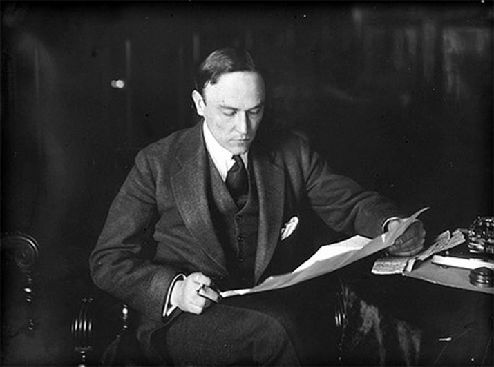
Mikhail Ivanovich Tereshchenko
With his comprehensive education, friendliness, external polish and internal beauty, he conquered everyone - he succeeded in a lot. In exile, M.I. Tereshchenko managed to create shelters for his disadvantaged compatriots, provided significant financial assistance for their improvement, and they did not even know who was doing it. Maybe he was trying to atone for February 1917?
During World War II he lived in England, then in Monaco. Mikhail Tereshchenko died in Monte Carlo on April 1, 1956.

There is a pond near the palace. The Andrushevskaya Church is visible across the pond.

This photo shows that there are two ponds and they are separated by an artificial dam.

Palace Pond.


Andrushevsky palace ducks).

Unfortunately, the palace itself is not visible from the opposite bank - the stupid house of an unknown architect is in the way.

The park also has a peninsula surrounded by an artificial water channel. Its abandoned remains remain.


Along the canal there is a road to the sugar factory. On the left are obviously outbuildings.

A platinum bridge on the Guiva River, which feeds the pond and canals.

Behind the bridge is the Guiva River itself, which is quite wide here. It flows along the Tereshchenko sugar factory.

The park around is very beautiful, but abandoned. Somewhere here grows a cork tree that is unique to us. We didn't find him. They say it is already reaching its end - and not because of age, but because it is being taken apart for souvenirs...

This house built in 1929 with a bust of Ilyich in a circle on the facade is quite interesting from an architectural point of view. It is located opposite the sugar factory


And here is the sugar factory itself. Old buildings built under Tereshchenko are visible. Yes, like almost everything here... At least it works well.

On January 26, 1919, the first Volyn Revolutionary Committee was created in the palace, headed by the Baltic sailor M. Popel; in June 1920, the headquarters of the First Cavalry Army was located. Here at the rally, from the balcony of the palace, S. M. Budyonny spoke (memorial plaques on the main facade of the building). The building currently houses a school.
In 1944, on January 9, the headquarters of the First Ukrainian Front moved from Svyatoshino near Kiev to Andrushevka, on the right bank of the Guyva, to Krasnaya Gorka, and was located in the hospital building. The Front was commanded by Army General Vatutin. Deputy Commander-in-Chief Zhukov was also here. The front troops completed the Zhitmoir-Berdichev operation, and the left wing of the front ended with the destruction of the Korsun-Shevchenko group of fascists. February 28, 1944 Mikhail Fedorovich Vatutin went to the location of the 60th and 13th armies. In the village of Milyatin, Ostrog district in the Rivne region, Vatutin was seriously wounded by Bendera. On February 29, the general was brought to Rovno and then to Kyiv, but it was not possible to save the famous military commander.

In addition to the interesting flora, there are many different birds in Andrushevka - we have already seen ducks and storks, and there are also swans that fly here. Someone else lives in this original birdhouse.

Occasionally you come across dogs like this...)

But these are not all the attractions of Andrushevka - if you drive from Andrushevka in the direction of Chervone (the next point of our journey), then on the right side not far away you can see a rather unique building - a private observatory!
From an interview for the newspaper "Segodnya"
“The creation of this scientific institution,” says the founder of the observatory, its director, sponsor, scientist and candidate of physical and mathematical sciences, Yuri Ivashchenko, all in one person. “Real fans worked on it. In order not to be unfounded, we kept the construction secret for a long time. Even then , when the six-ton dome was installed in 1999. The telescope was brought from the Elbrus region (Terskol). After a long and persistent struggle for it, the telescope was assembled by Yuri Lebedev himself. But the main pride of the creators was the S1C camera. “There are many scientific programs and projects to prevent asteroid danger and other threats from the Universe. They also tried to make the conditions for scientists at the highest level. The observatory has offices, equipment, cozy bedrooms, baths, lounges and even a tennis court.”
By the time we saw it, there were already two observatories. Great


Pyotr Mikhailovich and Mikhail Mikhailovich (Michelle) Tereshchenko
Recently, the son of Mikhail Ivanovich, who lives in France, visited his former possessions Peter Mikhailovich and grandson - Michel Terestchenko. The latter, as I know, recently even seems to be living in Ukraine and running his own agricultural business in Glukhov, for example, he exports honey to France.
Andrushevka
Once upon a time this village was called Andrusovka, and was located, like all the surrounding lands, on the territory of the Polish-Lithuanian Commonwealth. At the end of the 17th century. Adrusovka went to the eminent Berzhinsky family, and it was under them that it began to be called Andrushovka. Feel the difference. Andrushovka - it sounds proud! The Berginskys built a palace on the shore of the pond and laid out a park. In 1848, the first sugar factory in the region was built here, and in 1869 it was bought by the richest sugar refiners of Tereshchenko. In addition to the plant, they also got the rest of the village, along with the palace, park and pond.
The Tereshchenkos expanded the park and rebuilt the palace in the fashionable French neo-Renaissance style. The plant was also reconstructed and is still operating today. Surely that pre-revolutionary modernization under Tereshchenki remains the only one in the history of the Andrushovsky sugar plant to this day.
The palace was rebuilt again in 1975 - the second floor was completed. In 1919, the first Volynrevkom was organized in it, and in 1920 the headquarters of the First Cavalry Army, headed by Budyonny, settled in the palace.
 |
 |
 |
|
 |
 |
 |
 |
In 1897, 430 Jews lived in Andrushevka (16% of the total population), in 1923 - 388, in 1939 - 658 (10%), in 1989 - 47 Jews (0.4%).
After 1917, large food industry enterprises, sugar and alcohol factories began to operate in Andrushevka. This determined the migration of Jews - specialists and workers from other cities and nearby areas - to Andrushevka.
In 1925, immigrants from Andrushevka founded three Jewish agricultural colonies in the Kherson district (Kalinindorf national region): them. Chemerissky (26 people), “Jewish grain grower” (50 people), “Labor” (25 people).
After some time, two buildings of the former carpentry of the distillery were allocated for the ghetto. The buildings were surrounded by a barbed wire fence and Jews from nearby villages began to be driven there - Chervone, Zarubintsy, Volytsia, Gardyshevka, etc.
In April 1942, a second group was led to execution and in the same month Jews were shot in other villages - Staraya Kotelnya, Ivnitsa and Chervone.
Until August 19, 1942, more than 1,200 Jews passed through the Andrushevskoe ghetto. During this time, groups of Jews were taken from the ghetto to repair roads, and no one saw them again. They left the ghetto only to die.
A large number of old people did not survive the winter, and their bodies were thrown right outside the fence. With the onset of spring, everyone was driven out to the fields for agricultural work. The police selected the healthiest Jews to work in their gardens.
On August 19, 1942, at 5 o’clock in the morning, the surviving Jews were taken out of the ghetto and driven to the Andrushevsky forest, where they were shot.
Alex Balshin, http://www.yadvashem.org
 |
 |
Andrushevka, 2009, 2014
Andrushevka was occupied on July 5, 1941. Local police immediately began looking for Jewish activists and shot them on the spot, in front of their relatives and children. Thus, in particular, Mikhail Iosifovich Privan, a trade union activist of the Berdichev sugar plant, who brought his children to Andrushovka, was killed. Soon after the start of the occupation, Jews began to be herded into the village of Gardyshevka into the local school building. Jews from some nearby villages were also brought there.
On August 19, the first group of Jews was led through Andrushevka into the surrounding forests and shot there. The number and composition of this first group of victims is unknown. It is only known that they were shot in the Andrushevsky forest. Spector Pesya and her daughter were buried alive.
Here is a map of Andrushevka with streets → Zhytomyr region, Ukraine. We study a detailed map of Andrushevka with house numbers and streets. Search in real time, weather today, coordinates
More details about the streets of Andrushevka on the map
A detailed map of the city of Andrushevka with street names can show all the routes and roads where the street is located. Zhitomirskaya and Lenin. The city is located near. The Guiva River flows nearby.
To view the territory of the entire region in detail, it is enough to change the scale of the online diagram +/-. On the page there is an interactive map of the city of Andrushevka with addresses and routes of the microdistrict. Move its center to find Lysenko and Zozulinsky streets.
The ability to plot a route through the territory using the “Ruler” tool, find out the length of the city and the path to its center, addresses of attractions.
You will find all the necessary detailed information about the location of the city's infrastructure - stations and shops, squares and banks, highways and alleys.
An accurate satellite map of Andrushevka with Google search is in its own section. You can use Yandex search to show the house number on a city map in the Zhytomyr region of Ukraine/the world, in real time. Here
 Andrushevka Zhytomyr. Andrushevka. The park also has a peninsula surrounded by an artificial water channel. Its abandoned remains remain
 Colony - home in Diamond City Need an update?
 Finnish penny from the time of Nicholas II