Merv, city of infidels. "merv" you can still search Merv is ancient
The city where Abu Muslim proclaimed the Baghdad Caliphate
The largest historical and cultural reserve on the territory of modern Turkmenistan is included in the UNESCO World Heritage List.

In the first centuries of Islam, Merv was one of the most important centers of Muslim civilization. Its heyday dates back to the 11th–12th centuries, during the reign of the Great Seljuk dynasty, whose empire stretched from the left bank of the Amu Darya to Palestine. In those days it was one of the most beautiful cities of the East, and today it is the largest archaeological park in Central Asia near the small town of Bayramaly, where unique mausoleums of Islamic warriors and still revered shrines, numerous ruins of mosques, palaces and clay castles, caravans have been preserved. sheds and bazaars, as well as kilometers of powerful fortress walls.

Merv is the name of not only one of the oldest Asian cities, but also the entire surrounding area in the old delta of the Murghab River. Since time immemorial, these lands have attracted people with their fertility and abundance of water. In the Bronze Age, the fertile region, later called the country of Margush, or Margiana, was inhabited by agricultural and semi-nomadic tribes, who created a unique culture of the ancient Eastern type. But on the plain, where city life was in full swing four thousand years ago, the Karakum desert now stretches, and ancient settlements discovered by archaeologists of the twentieth century are slowly absorbing the sands, or they are leveled with graders by yesterday's collective farmers, who have now become unpunished invaders of protected lands, so tempting for new irrigation. Thus, history is already disappearing before our eyes, its priceless evidence is disappearing, often not even having time to become the property of science.

Against the backdrop of an extremely scarce written tradition, when entire eras have sunk into oblivion without leaving any memory of themselves, preserving the heritage of ancestors is becoming a serious problem on a national scale in Turkmenistan. Ancient Merv, declared a state historical and cultural reserve back in 1988, and since 1999 included in the UNESCO World Heritage List, serves as an example of how monument protection authorities are trying to resist the greed of entrepreneurs and the indifference of local authorities. With the support of international organizations and foreign research centers, Turkmen specialists are implementing projects for the study and conservation of individual ancient structures and are systematically working to form their social status. This routine but necessary work has nothing in common with the official campaigns of recent years, such as the celebration of the 2500th anniversary of Merv - a fictitious anniversary that was postponed and was never carried out.

This age of the city is nothing more than a vulgarization of history, especially characteristic of Soviet ideology and not having any serious scientific basis. Neither archaeologists nor ancient orientalists would dare to say when exactly a settlement arose on the site of Merv. There is indirect evidence that this happened around the 7th century BC, when the Bronze Age oases in the lower reaches of the Murgab delta, on the site of the current Erk-Kala settlement, which towers over the entire area, had long been abandoned.
But then it was only one of many settlements, far from the largest and not the most important. However, it was destined to become over time an important political center, which under the Achaemenids turned into a powerful citadel, and after the campaign of Alexander the Great began to be called Alexandria of Margiana.

Erk-kala is the oldest core of Merv, which is an oval in plan. Later, a square Hellenistic city was added to it on the western side - Antioch of Margiana (now Gyaur-kala), which developed together with Erk-kala under the Parthians and Sassanids and accumulated a twelve-meter cultural layer! After the Arab conquest, Sultan-kala grew even further to the west, but close to it - Merv of the Abbasid and Tahirid era, and the Seljuk capital of the mid-11th century. At the beginning of the 15th century, when it was already uninhabited, Tamerlane’s son Shahrukh erected the Abdullakhan-kala fortress two kilometers to the south, to which the last Merv settlement, Bayramalikhan-kala, was added at the end of the same century. This is how, over centuries, the building site of Merv drifted along with the receding water, leaving ruins almost nowhere covered by later layers, which now greatly facilitates the work of archaeologists. But before this nomadic city, moving in space, stopped forever, becoming a museum-reserve, it experienced a turbulent history of the rise and fall of kingdoms and dynasties, countless wars and destruction, but at the same time creation, the revival of life after acute social upheavals.

In 651, 19 years after the death of the Prophet Muhammad (peace and blessings be upon him), Yazdegerd III, the last monarch of the Sassanid state, was killed in a small village near Merv. This date was a milestone that marked the Arab conquest of Iran and Central Asia, as well as the beginning of the spread of Islam among the peoples of this region who previously professed Zoroastrianism, Buddhism, Christianity, Manichaeism and local forms of paganism. Immediately after the capture of Merv, the Benu-Makhan cathedral mosque was erected in the center of Gyaur-kala, which later became an integral part of the cult-memorial complex, which developed until the 11th century. At this site, archaeologically recorded masonry walls and the remains of a minaret, as well as semi-columns made of carved ganch with rich ornamentation that decorated the mihrab. When the very first cathedral mosque became cramped, another was erected at the city gate on the Razik canal, and in the middle of the 8th century the next one was built even further to the west, on the Majan canal. By this time, Gyaur-kala was almost deserted as a result of the policy of the Arabs, who everywhere evicted residents from fortified shakhristans. As a result, rabad began to expand, where the main life of the city moved.

The center of the future brilliant Merv was the western suburb of Gyaur-Kala. It was founded by the legendary Abu Muslim, the leader of the Abbasid movement in Khorasan, who in 748 led Abbasid supporters to Merv to proclaim a new dynasty, which soon defeated the Umayyads in the struggle for power in the Arab Caliphate. Having settled in Merv, he moved the government residence from the old city, Gyaur-kala, and built a new one near the Majan canal - where Sultan-kala later grew. The palace of Abu Muslim, known as Dar al-imara and built around 750, was an elaborate building that, according to the description of the Arab geographer al-Istakhri, who saw it a century and a half later, included a domed audience hall, four iwans and a courtyard. This fusion of Sasanian architectural forms (dome and iwan) for centuries determined the character of Islamic architecture in this part of the world - not only civil, but also cultic.
Despite the assassination of Abu Muslim in 755, Merv remained the main political center for the entire Abbasid, or, as it was also called, the Baghdad Caliphate and even for some time became the de facto capital of the entire Islamic world.

This was at the beginning of the 9th century, after the Khorasan governor of the Caliphate al-Mamun, the son of Caliph Harun al-Rashid, arrived here. In 813, al-Mamun himself became caliph, but for a long time after that he lived in Merv, sending from there all the instructions and appointments throughout the Arab state. During this time, Merv experienced a short but brilliant period in its history. There are no architectural monuments of the 9th century left, but it is known that the mentioned Benu Mahan mosque was restored in the center of Gyaur-kala. A large underground water tank with a collapsed dome is the only landmark by which one can now find the former complex of this oldest mosque. Meanwhile, Merv, located on the eastern outskirts of the Caliphate, was not very suitable for the role of an imperial center, and al-Mamun nevertheless moved to Baghdad, and the city again became the main center of the Caliphate province of Khorasan, where in 821 a governor was appointed - Tahir ibn Hussein . According to al-Istakhri, he wanted to move the center of Merv even further to the west and erected a number of buildings along the Hurmuzfarra canal.
The first large structures that greet visitors to the reserve today are the mysterious clay castles Big and Small Kyz-Kala with their harsh rhythm of tightly pressed semi-columns forming corrugated facades. There are different assumptions about the age of these gigantic dwellings. English researcher Hugh Kennedy recently substantiated the hypothesis that these could very well be the buildings of Tahir. And if the features of their designs and building materials cannot serve as accurate indicators in this case, then the presence of a mihrab in one of the premises of Greater Kyz-Kala clearly indicates that the building was already built under the Arabs. Corrugated keshki are typical for Central Asian architecture, there are many of them not only in Merv and its surroundings, but also in Khorezm, they were found in Bukhara and Termez, but they are completely absent in Iran. It is clear that this is a purely local architectural type, dating back to the pre-Islamic past and continued to be reproduced at least until the 12th century, not only in mud brick, but also in burnt brick; A striking example of this is Rabat-i Malik, the steppe residence of the Karakhanids in the Bukhara oasis.
In the 10th–11th centuries, an era of unprecedented cultural upsurge began, when the best minds of the Muslim world, poets, artists and architects flocked to Merv, leaving their imperishable works to their descendants. It is enough to name Omar Khayyam and Fakhr ad-din Gurgani, who lived here for many years, the author of the romantic epic “Vis and Ramin”, which contains the following lines about its architecture:
If the city enchanted hearts,
Imagine the grandeur and splendor of the palace!
It sparkled with paintings of walls and towers,
Decorated with Chinese patterns.
However, depending on the mood of the heroine of the poem, the perception of the city also changes:
This brazier is Merv, not the capital,
Not a city, but a deep dungeon.
A painted palace, a priceless palace,
Gehenna seems fiery to me.
And yet, love for the place where Gurgani spent many prosperous years as a poet at the court of the Seljuk Sultan Togrulbek evoked completely different emotions in him:
Beautiful Merv, shelter of earthly rulers!
Merv is beautiful, where the flower beds bloom!
Merv is beautiful in winter and in the summer heat,
It is beautiful in autumn and spring!
Who saw Merv, who settled in it,
Will he find happiness in another city?
(Translations by S. Lipkin)
Exactly a thousand years ago, Merv became the largest city in Central Asia and one of the largest in the entire Muslim East: together
with its suburbs, its area reached 1800 hectares, and its population was 150 thousand people. Considering that the majority of cities in that era had from two to five thousand inhabitants, one can imagine the scale of Seljuk Merv. Literally every kilometer here you can see one or another evidence of the distant past. Around the metropolitan metropolis, since Parthian times, there has been a dense network of towns and separate rich estates. Sometimes it is not clear where the remains of the city itself are, and where there was a conglomerate of overgrown villages. In the 10th century, city dwellers made up, according to some estimates, about 40 percent of the total number of inhabitants of the oasis.
Under Sultan Melik Shah, at the end of the 11th century, the adobe wall of the rabad, the central square part of the Sultan-kala, was erected or completely rebuilt. The wall was surrounded by a deep and wide ditch, and along the perimeter of the walls there were about two hundred semicircular towers with a diameter of 4 m with two-tiered vaulted chambers for shooters. The walls reached a height of 10–12 meters with a width
6 meters; Inside there were casemates and secret staircases. Before the Mongol invasion, the slender walls and towers of Sultan-Kala were reinforced on the outside with thick cases made of mud brick. The city gates were located on two mutually intersecting axes - powerful structures made of baked bricks, pushed forward from the line of the wall. One of them - the Firuz gate on the western side - was opened by archaeologists. This is in many ways a unique fortification device with a labyrinth; its outside gate part was decorated with cladding made of figured burnt bricks of eighteen types!

In the northeastern corner of Sultan Kala is Shahriyar Ark, a walled citadel of Seljuk Merv. In its northern part there are the remains of adobe walls and arches of former barracks, and in the center is the so-called ruler’s house. It was a two-story building with a square, four-aisled courtyard, built of adobe and only on the facades faced with figured baked bricks. Next door are the ruins of another adobe monumental building, which contained one elongated and high hall, covered with a vault on supporting arches. The facades are decorated
in the old traditions of corrugated locks. Perhaps it was a sofa - the place where the state council met. Among other adobe monuments of the 11th–12th centuries, a country residential building 4 kilometers west of Sultan-Kala stands out. Its brutal forms, the composition of the same type of facades with slit-like loophole windows and the planning structure with a central domed hall indicate the sustainability of the traditions of the castle architecture of pre-Arab Merv.
Almost on the spot where Abu Muslim's palace was located, in the middle of the 12th century (no later than 1152), the mausoleum of Sultan Sanjar, the last ruler of the Great Seljuk dynasty, was erected. It was part of an ensemble of large royal buildings that towered in the center of Sultan Kala. Here there was a palace and a cathedral mosque, to which the Sanjar mausoleum adjoined one of its facades. Many evidence points to its dominant role: “...a blue dome rises above it, which is visible at a distance of one day’s journey” (Yakut al-Hamawi, XIII century), “the largest building in the world” (Rashid ad-din , XIV century),

“One of the greatest buildings of the kingdoms of the universe, so strong that damage cannot touch it” (Isfizari, 15th century). And in its current state, the mausoleum of Sultan Sanjar evokes admiration. This is a huge cube that is crowned by a dome with a diameter of 17 meters. The outer dome, covered with tiles, has not survived, but was restored without cladding in 2004. The height of the dome space of the hall is 36 meters. In the upper part of the cube there is a bypass gallery, revealed on the facades by the rhythm of openwork through arches.
The decor of the gallery uses figured sets of burnt bricks and carved ganch with stylized floral patterns and epigraphy. The interior features wall paintings done in blue and red on a white background. The design of the unloading arched devices and the double shell of the dome of the Sanjar mausoleum is one and a half centuries ahead of the ideas of the builders of the Oljeitu-Khodabendeh mausoleum in Soltaniye (northwest Iran) and 300 years ahead of the ideas of Philippe Brunelleschi, the creator of the dome of the famous Florence Cathedral.

The majestic tomb of the Sultan stands alone in the desert landscape, where time has literally razed the dense network of city blocks to the ground. Only recently, right opposite the entrance to the mausoleum, archaeologists from Great Britain began to excavate the remains of a large bazaar from the time of Abu Muslim, but known from medieval sources as a cathedral mosque with a minaret, the Sultan's palace, as well as other extraordinary buildings, including ten libraries, an astronomical observatory in which Omar worked Khayyam, are not even localized.
The high level of architecture in Merv is also evidenced by the small memorial mosque of Muhammad ibn Zeid, built in the suburbs near the ceramist quarter in 1112–1113. The main facade of this symbolic building is designed in the form of three arches with intermediate arched niches and frieze horizontal inserts above them. Carefully polished figured bricks and girikh give it a rich pattern. In the interior there are traces of ornamental painting, as well as a brick Kufic inscription and a rare multi-bladed mihrab covered with polychrome painting. Stylistically close to him is another monument of the first quarter of the 12th century - it is called, according to later tradition, Khudaynazar-ovliya. It also belongs to the category of portalless centric mausoleums, the basis of the decor of which is the textural qualities of baked brick.

In 1153, Merv was captured by Ghuz nomads and brutally plundered. The ensuing anarchy against the background of feudal wars for the possession of Khorasan, which lasted for several decades, interrupted construction activity. Only after becoming part of the state of the Khorezmshahs, the city was able to partially recover from the damage caused, but already in 1221 it was completely destroyed by the Mongols. Almost 200 years later, under the Timurids, Merv was reborn, but could no longer reach its previous level not only due to frequent political cataclysms, but also natural factors. The climate became drier, pastures were depleted, Murghab became shallow, sown areas were reduced, and people began to leave their habitable places.
To the north of the fortress wall of Abdullakhan-kala, in the 15th century, a charbagh was laid out - a huge park with the summer residence of the Merv ruler. The entrance to it was formed by an arched gate, and the ceremonial park pavilion rose strictly along the axis. The only surviving Merv ensemble from that period is the mausoleum of the Ashabs, the companions of the Prophet Muhammad (peace and blessings be upon him), buried in Merv back in the 7th century. Over their graves under the Timurids, marble slabs with magnificent carved decoration and inscriptions were placed, hidden by domed kiosks, and behind, in the background, two adjacent vaulted ivans, lined with blue and light blue tiles, were erected. There is nothing behind them - they serve only as a monumental backdrop for both graves. Even in the vicinity of Abdullakhan-kala you can see yakhdans - huge, almost conical adobe domes, erected directly on the ground. These were public refrigerators: snow, densely packed in winter, was stored in them all year round, covered with a compressed layer of camel thorn.
Several centuries passed before Merv opened up to the world again, now thanks to travelers and scientists from Europe and Russia. The ancient city and its surroundings became the object of close interest of orientalists and archaeologists. The pioneer was a thirty-two-year-old professor at the Faculty of Oriental Languages at St. Petersburg University, Valentin Zhukovsky, who came to Merv in 1890 on instructions from the Imperial Archaeological Commission. It was he who carried out the first truly scientific presentation of the history and study of the monuments of the Mary oasis. His fundamental work, which at one time was awarded the gold medal of the Russian Academy of Sciences, has not yet lost its practical value. In the autumn of the same 1890, Merv was recorded in detail by the French photographer Paul Nadar, who left Paris on the famous Orient Express and arrived here along the newly built railway through Istanbul, Tiflis, Baku, Krasnovodsk and Ashgabat. More than a thousand photographs were the result of a journey that combined the curiosity and skill of a man who, using a new type of transport and the quality of photographic equipment of those years, was the first to present previously inaccessible images of the mysterious East to the West. In 1904, Merv was visited by an American expedition of the Carnegie Institution led by Professor Raphael Pampelli. And although his research at Gyaur-Kala was short-lived and episodic, it was they that marked the beginning of the archaeological study of the Murghab oasis.
In the 20th century, academicians Vasily Bartold, Mikhail Masson and the South Turkmenistan Archaeological Complex Expedition (UTAKE), which he headed from 1946 to 1986, made a great contribution to the study of the history and culture of Merv. Several volumes of the works of this mission are dedicated specifically to Merv, not to mention a number of monographs, scientific collections and articles about his monuments, many of which were identified and published by the Utahns. Finally, since 2001, the International Merv Project has been carried out, organized by the Institute of Archeology of University College London on the basis of the State Historical and Cultural Reserve “Ancient Merv”. Dozens of young specialists from Turkmenistan, Great Britain, Germany, Denmark, Iran, China, the USA and other countries undergo internships here, mastering the wisdom of the profession, and develop their own scientific topics, extracting material from the inexhaustible treasury of Merv.
Ruslan Muradov.
Deputy Head of the National Department of Turkmenistan for the Protection, Study and Restoration of Historical and Cultural Monuments.
Website materials used: http://islam.ru/
, China), now Margiana is recognized as the fifth such center. The capital of this ancient country was presumably Gonur, traces of which are located 70 kilometers northwest of Bayramaly.
In the early Middle Ages, the huge ancient city was deserted, houses, workshops, and temples were abandoned. Around the years, Merv was captured by the Hephthalites, who successfully acted against the Sassanids. At the end of the century The Sassanians managed to return the oasis, and in the century. Khosrow I Anushirvan ordered the repair of many buildings in Merv, and the city came to life, once again becoming a cultural and craft center.
As part of the Arab Caliphate
The further fate of the city was very difficult. Immediately after the departure of the army of Ismail I, the Uzbek ruler Ubaydullah Khan captured Merv several times, plundering it. For almost 80 years, Merv was alternately annexed to their possessions by the Shaybanid princes, until finally, the Safavid Shah Abbas I firmly secured it to his possessions in 1996. On his orders, the city walls were rebuilt. The new ruler Bektash Khan from the Turkmen Ustajli tribe, appointed by Abbas I, improved the fortification: the walls, surrounded by a deep ditch, were repaired, and a number of defensive towers were erected along them. Large reserves of weapons, clothing and food were concentrated in Merv itself.
After the death of Abbas, I year) the Khorezm ruler Isfendiyar Khan tried to take possession of Merv, but was defeated by the Merv commander Ashir Khan and hastily fled, leaving his property. The attempt of the Uzbek khan Imamkuli to capture the city also ended in failure. In the year, the townspeople, under the leadership of their ruler Hadji Timur Khan, twice repelled the assault of the Bukhara atalyk Khushike-biy and survived.
The struggle for the city between Persia, Bukhara and Khiva
By the time of the rise of Nadir Quli Khan from the Turkmen Afshar tribe in Iran, Merv was completely in the hands of the Qajar Turkmen, who fought the local Tatars. The population of Merv turned to Nadir Khan for help. Having expelled the Tatars from Merv in the summer of the year, the khan headed to Mashhad. But the Tatars unexpectedly returned and captured the city. Nadir Khan was forced to send his brother Ibrahim Khan there, who destroyed the Sultanbent dam, leaving Merv without water. The Tatars surrendered the city, but hard times came for the population. Many residents were resettled to other areas of Khorasan. Only ten years later, when Nadir Quli Khan became the Shah of Iran, he gave the order to restore Merv. Not only the previously evicted residents returned there, but also 3 thousand families of Khorasan peasants were sent there. Special workers were allocated for the repair of the Murgab dam, as well as two hundred camels and three hundred donkeys, who brought everything necessary for repairs. In Merv there were no longer any appanage owners; all land and water became the property of the state.
Thus, Merv became an important outpost for Nadir Shah's further conquests in Central Asia. In the year, he ordered the ruler of the city, Shahkuli Khan, who was appointed by him, to do everything necessary for the trip to China. In a short time, Merv artisans produced 70 cannons and cast 14 thousand cannonballs. Three hundred artillerymen improved their ability to fire guns. Merv turned into a military city and its fortress with 44 towers was considered impregnable. During the year, another 50 cannons, 20 thousand cannonballs and iron reserves were brought to the city. All types of troops were concentrated there. But all this was destroyed after the death of Nadir Shah in the year. The city passed from hand to hand to Iranians, Afghans and Bukharans. The reign of Bayramali Khan dates back to the end of the 18th century, to whom a new revival of Merv (Bayramali Khan-kala) is attributed. But he did not rule the city for long as he was killed in a battle with the Bukhara emir Shah Murad. Then the emir failed to take possession of Merv. He did this during his second campaign, when he destroyed the dam and took 15 thousand dead to Bukhara, leaving the brothers Omar-biy and Fazil-biy in the city. Two years later, the residents of Yerv expelled them, and Bedel-Mirza became the khyakim of the city, whom Shah-Murad soon replaced with his son Din-Nasir-bek. After the death of Shah Murad, a struggle began between his sons for Merv. In the year, Emir Haydar captured Merv and took part of the population to Bukhara, the other part went to Mashhad. Only about 500 Qajars remained in Merv.
In the early 1820s, the Saryks and Tekins arrived in Merv, who repaired the walls of Bayramalihan-kala and in the year opposed the dominance of the Khiva and Bukhara rulers. Continuous wars did not prevent the Turkmen from partially reviving the old city. But in parallel, another core of the oasis was already being formed, which later became the main one. At the beginning of the 19th century, after another destruction of the Sultanbent dam, the main channel of the lower reaches of the Murgab shifted almost 30 km west of the ancient Merv settlements. First, the Teke village of Garayap (north of present-day Mary) arose on the left bank of the new riverbed, which then served as a Teke military base for several decades; The right bank at that time was occupied by saryks. In the same year, the Turkmens of both tribes managed to drive the Bukharians out of the oasis, after which they temporarily recognized Khivan citizenship. The authorities of Khiva tried to restore Sultanbent in order to breathe life into historical Merv, but they were unable to do this, so in the year they erected a fortress on the left bank of the Murgab, at the Egri-Guzer crossing, which became the residence of the Khiva governor and the administrative center of the entire oasis. A Tekin aul immediately grew up near the fortress - the immediate predecessor of modern Mary.
The entire subsequent history of Merv until the 1870s was a constant struggle between Khiva, Bukhara and Persia for the possession of a fertile oasis, and the resistance of the Mary Turkmens defending their independence. In - gg. the Khivans made five unsuccessful campaigns against Merv. On March 12 of the year, Muhammad Emin suffered a crushing defeat from the Tekins of Serakhs, led by Kaushut Khan. The Khan of Khiva himself died in the battle. After these events, Serakh Tekins moved en masse to Merv. Having strengthened themselves, they completely defeated the Persian army under the command of Hamza Mirza Eshmet Daule.
Russian rulers
In the year, fearing the invasion of Russian troops, who had conquered Khiva the day before, the Mary people began construction of the last, most impressive in size and impregnable fortress, called Kaushuthan-kala. It stood on the banks of the Murgab, on the site of the modern city of Mary, but did not justify its defensive purpose: Russia managed through diplomatic actions to achieve the peaceful annexation of the entire oasis. In 1992, the International Project on Merv, organized by the Archaeological Institute of the University of London, was carried out at the Erk-Kala Gyaur-Kala settlements.
Used materials
- Website of the Ministry of Culture of the Republic of Turkmenistan:
In the southeastern part of the state of Turkmenistan is the oldest city in Central Asia. It stands on the banks of the Murgab River, near the city of Mary. Today, Ancient Merv is a ruin, which is a World Heritage Site for all mankind.
During the era of the Margiana civilization, the Merv oasis was already inhabited. This suggests that it existed for another 3-2 thousand years BC. In our era, the city became one of the main centers of Parthia. At that time its area was 60 square meters. km.
After the Arabs conquered Central Asia in the 7th century, the city became a springboard for conquest expeditions to the east and north. Over time, Merv turned into a book center for Arabs. This happened thanks to the 10 libraries that were located here.
During the reign of the Samanid dynasty, Merv truly flourished. This happened in the 12th century, when Sultan Sanjar turned it into the capital of the Seljuks. The buildings inside the city were amazing - they were more majestic than the buildings of Baghdad and Constantinople.
But already in 1221 the Mongols mercilessly destroyed the beautiful city. The Timurids made an attempt to revive Merv, but it was never able to achieve its former greatness.
The third largest city in Turkmenistan is Mary(until 1937 - Merv), located in a large oasis in the middle of the Karakum sands in the delta Murgaba. Mary was founded in 1884 as a Russian military-administrative center 30 kilometers from the ancient city. Now it is the largest center of a rich cotton-growing region, a major transport hub and the main center of the country's gas industry - the main source of income for Turkmenistan. The city is interesting Museum of History with an extensive collection of archaeological finds, Turkmen carpets, national dress, silver and superb embroidered clothing of various local tribes. Local history and ethnographic exhibitions are also noteworthy.
Neighborhoods of Merv
The oasis of Merv (40 km east of Mary) is one of the most ancient regions of Central Asia that has mastered irrigation - the first traces of an irrigation system in these parts date back to the Bronze Age. Therefore, it is not surprising that one of the largest cities of the ancient world grew here -. The origin of Merv is shrouded in mystery, one thing is known for sure - the first written mentions of it appear in the Avestan chronicles around the 8th-6th centuries. BC. They lived and worked here Omar Khayyam, al-Samani, Imamad din-Isfahani and other great thinkers of the Middle Ages.
The modern ruins include at least five ancient settlements - Erk-Kala, Gyaur-Kala, Sultan-Kala, Abdullakhan-Kala And Bayramalihan-Kala, surrounded by a wall and the ruins of other fortifications and religious buildings (the exact boundaries of the city are still unknown). Most of them are badly destroyed, some of them are only heavily eroded earthen hills, but even taking this into account, Merv continues to remain one of the most unique historical monuments. Today it is listed as a UNESCO World Heritage Site as the best-preserved ancient center of the Silk Road.
Among the most interesting historical monuments one can note Mausoleum of Sultan Sanjar Dar al-Akhir (1140 AD) almost 40 m high, Sultan-Kala, Shazriar-Ark citadel, ruins of walls Abdullakhan-Kala (XV century), ruins of a fortress and towers Bayramalihan-Kala, ruins Kyz-Kala fortress (VI-VII centuries AD), mausoleums of Al-Hakim ibn Amir al-Jafari and Buraidah ibn al-Hussein al-Islami (XV century, place of pilgrimage), mausoleum of Muhammad ibn Zeid (XII century), Talkhatan Baba complex with mausoleums of Talkhatan Baba, Imam Kasim, imam Shafi and Imam Bakr of the Seljuk era, Yusuf Hamadani Mosque(XIII century, modern reconstruction was carried out in the 19th century), ruins Yerk-Kala fortress (VI century), ruins of a Christian temple and a Buddhist monastery in Gyaur-Kala(ancient Antioch Margiana), mosque ruins Benny Makhan(“Friday Mosque”, 7th-12th centuries), high walls of fortress-like structures Big and Little Kyz-Kala, Kyz-Bibi mausoleum, as well as numerous remains of baths, palaces, state halls and other buildings.
Also worth attention mausoleum of the Dandankan and Talkhatan Baba mosque(XII century, 30 km southeast of Merv), keshk (fortified house) Akuili-Koushuk (IX-XIII centuries), single Haram-Keshk castle(7 km north of Gyaur-Kala, IX-XIII centuries), Durnali fortification(25 km north of Gyaur-Kala, I-II centuries), Gebekli settlement(32 km northwest of Gyaur-Kala). Many archaeological finds discovered during excavations of ancient cities are now on display in the beautiful United Historical Museum of Merv.
Merv photo


The ancient city of Merv is one of the oldest cities in Central Asia and the whole world. Merv occupies one of the largest archaeological sites in Central Asia. Here are the ruins of five different fortifications. The ancient city of Merv is also famous for the brightest minds of the Islamic world, such as Al-Khwarizmiya and Omar Khayyam, who lived and worked there.
The ancient city of Merv is located 30 km east of the city of Mari, the capital of the province, or vilayet of the same name, located in the southeast of Turkmenistan, bordering Afghanistan. Merv lies on one of the main branches of the ancient Silk Road, along which trade took place between Europe, Africa and the Far East. Historically, Merv was also an important starting point for the 180-kilometer journey through the desert northwest to ancient Amul (today Turkmenabad), located on the banks of the Amu Darya River. The ruins of ancient Merv are located next to the small town of Bayram Ali, a Russian garrison town founded in the early twentieth century.
A wide delta of rich alluvial lands created by the Murghab River, which flows north of Afghanistan, forms an oasis on the southern edge of the Karakum Desert.

The first written mentions of the ancient city of Merv date back to the 8th-6th centuries. BC. It is known that ancient chroniclers gave large cities the most pretentious names possible, for example, Samarkand was called the “Pearl of the Islamic World.” But here are the names that were given to ancient Merv: “The Soul of the King”, “The City on which the Universe rests”, “Mother of the Cities of Khorasan”. Well, it is very likely that the ancient city fully justified all these names, because even its ruins create unforgettable impression.

What remains of five settlements - Gyaur-Kala, Erk-Kala, Sultan-Kala, Bayramali-khan-Kala and Abdullah-khan-Kala, allows us to reconstruct the chronology of the area for many centuries. Some of the most interesting sights of Ancient Merv are the tomb of Sultan Sanjar, the Shakhriyar-ark citadel, the Sultan-Kala settlement, the ruins of fortresses, a Christian temple and a Buddhist monastery. Big and Small Kyz-Kala, ruins of palaces, baths.

Currently, the ancient city of Merv is listed as a UNESCO World Heritage Site as the best-preserved ancient center of the Great Silk Road.
 History of Bosnia and Herzegovina Bosnia and Herzegovina description of the country
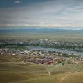 "My City Republic of Tyva
 Map of the Republic of Chechnya detailed from satellite