The Kingdom of Mustang is a mysterious country of the Himalayas. Forbidden Kingdom Mustang Secrets of the Ancient Kingdom of Luo
Blogger Ivan Dementievsky writes:
This forgotten or, conversely, God-preserved place is located high in the mountains, on the border between Nepal and Tibet. Until recently, it was completely impossible to get there; only in 1991, the King of Nepal allowed ordinary tourists to visit this region. But even with permission, the traveler faces a difficult path, full of hardships and hardships, at the end of which amazing discoveries await. At an altitude of 3,700 meters above sea level, in a small valley is the capital city of Lo Manthang.
View of the city of Lo Manthang. On the left is a fragment of the royal “palace”, although, when compared with the housing of the rest of the inhabitants, the king’s house is really a palace.
The first written mentions of the territory of Lo are found in the Tibetan Chronicles of Ladakh, they date back to the seventh century. At that time, this territory was under the control of Tibetan governors who had their residence in Tsarang. In the mid-15th century, the viceroy's son Ame Pal, sensing that the power of the Tibetan state was weakening, took advantage of the opportunity and declared the Luo territory an independent kingdom. This happened in 1440. The history of Lo's independent existence is described in the book of Molla, which was kept for many centuries in the monastery in Tsarang.
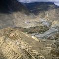
Bird's eye view of Jomsom. Traditionally, it is from here that the walking path to Mustang begins along the bed of the Kali Gandaka River.

But the path, like a villainous fate, winds not only along the bottom. Sometimes it takes off to passes of 4000 meters. Sometimes travelers have a hard time on such a path. But, as they say, the one who walks can master the road.

Ame Pal is the unifier king, the builder king. External aggression avoided Law for almost a century after its founding, and it was a time of flowering of religion and a time of prosperity for all classes. At that time, the climate was much milder, and the land of Mustang was more fertile. Ame Pal annexed vast lands and built fortresses and monasteries at strategic points. If the monasteries still stand and some of them are maintained in a tolerable condition, then only ruins remain of the fortresses.
Indeed, if you look closely, you can see many ruins along the way to the capital of the kingdom. Among the ordinary houses one can discern chortens and monasteries of the pre-Buddhist Bon religion and the thick walls of fortresses.

One of the famous Kecher dzong fortresses is located near Lo Manthang on the top of a narrow ridge dividing northern Mustang into two valleys. All fortresses in Mustang are rectangular in plan. But Kecher looks different. According to legend, Ame Pal's father, the governor of Lo, instructed him to build fortifications and restore order in the northern lands. At that time, the warlike prince Demon “Black Monkey” ruled at the sources of the Kali-Gandaka River. Ame Pal built the Kecher fortress, the Demon “Black Monkey” was indignant - the sharp corner of Kecher looked directly at the gates of his fortress and thereby directed evil spirits. Ame Pal rebuilt the walls of Kecher, making them round, and changing the location of his gates. But this did not help the “Black Monkey” Demon; a few years later he was defeated and his fortress was destroyed.
Another legend tells how Ame Pal chose the location for the capital. He planned to move his residence from Tsarang. After praying for the night, he set out with a herd of goats. He followed them until the goats stopped. The place turned out to be not far from the Kecher fortress. So Ame Pal chose the place for Lo Mantang, and since then the goat's head has been the symbol of the city. By the way, it was the name Lo-Mantang that gave the modern name to the territory of the kingdom - Mustang. This is how cartographers simplified the word Mantang. The appearance of the capital has hardly changed since the time of its construction by Ame Pal.
In the vicinity of the capital, a day's travel (for the average tourist), there are several monasteries and small villages.

The next era of prosperity is associated with the names of three saints, as they are called in Lo: Ame Pal's son Angun Zampo, his steward or, as we would call it, minister, Kalun Zampo and Ngorchen Kunga Zampo - the famous lama who contributed to the spread and strengthening of Tibetan Buddhism in Lo . But at the end of the sixteenth century, east of Lo, the state of Jumla strengthened, and a series of devastating wars began. Lo fell under vassalage, the power of the dynasty was preserved, but the tribute was high. The heyday has come to an end. Today there are no traces left of the warlike Jumla, but the kingdom of Lo has survived.
At the end of the eighteenth century, Jumla was conquered by the Garkhali, the sovereigns of Nepal. And Lo simply came under the control of the Nepalese Royal Family. The Nepalese retained Lo's autonomy and royal authority, calling the ruler of Mustang a rajah. The king in Lo is the administrator, the supreme judge, the moral authority, and royal power is the axis of the structure of social life.
Four decades of isolation in Mustang (from 1951 to 1991) undermined trade, one of the activities of the Lo-pa people, and had a heavy impact on living standards, which were already not very high. But the difficulties did not in any way affect the Lo-pa’s attitude towards life: their natural goodwill and caring attitude towards each other, the ability to live with what is given to you today and welcome the coming of a new day have not gone away.
Altitude and November take their toll. The weather couldn't be worse. Now the sun is shining, now a squally wind is blowing with a whistle, and even with snow. It is no wonder that so few people live in this inhospitable land.

Until now, some nomads lead the same lifestyle as their distant ancestors.

They work from infancy to old age. However, the appearance of the people of Luo is very deceptive. The fierce wind and scorching sun quickly turn young people into old men and women.

Lo Manthang
The capital of Mustang was founded in the mid-15th century. And the appearance that now appears to travelers is not much different from the city built during the reign of Ame Pal (1387-1447), the first king of the independent state of Lo. The main feature of the city is the wall around it, in which stone masonry alternates with adobe blank walls of houses. You can enter the capital only through one gate, which closes after dark. The wall surrounding the city is not only a tribute to the warlike times of the founding of the Kingdom of Lo, but also protection from the local climate and from destructive winds.

By European standards, Lo Mantagne seems like a tiny medieval town that has miraculously survived. True, at the time of its founding it was a large urban settlement compared to other Tibetan cities. Architecturally, Lo Mantang is a regular rectangle surrounded by a wall. Just over one hundred and twenty houses in the city are adjacent to each other with walls. The main building is the royal palace, the winter residence of the reigning king, close to the city gates and the main city square, which gives the impression of simply being a fairly large room. During the summer, the kings of Mustang prefer to live in a more modest palace outside the capital. Lo Mantagne has four monasteries, three of which were built during the time of Ame Pala. One of them, Champa Lakhang, is known as the “Castle of the Coming Buddha”; the golden statue of Maitreya - the Buddha of the Coming - standing in it was the largest in the entire Tibetan world.

A young monk at a meal. According to tradition, from each large family one boy was sent to a monastery. Now monasteries are like schools where they teach various subjects. People understand the importance and value of education.

The city is divided into four quarters, each with its own manager. According to tradition, the houses of noble families are built on three floors, while the rest are built on only two. There are twelve houses of aristocrats, they are scattered throughout the city. An ordinary house for a metropolitan resident: two floors, built of unbaked bricks, a flat habitable roof. The floor is smeared; it is simply periodically swept and watered, creating dampness in winter that is unbearable for a Westerner. The first floor is a winter floor, usually without windows to preserve valuable heat. The rooms on the second floor overlook the roof, where the main life is concentrated in the summer. The main room in lo-pa houses is the prayer room. This is where guests are accommodated.
The roofs of the houses of Lo Mantang, like any settlement in the country of Lo, are decorated along the perimeter with a strategic winter supply of fuel - gnarled rhizomes of bushes that are collected in the mountains. But in the time of Ame Pal and until the nineteenth century, the appearance of the Mustang was not as deserted as it is now. Climatic changes in the Tibetan Plateau, when, as the Lo-pas say, “the water left,” turned a region that was quite prosperous in nature into a desert area, where water and wood are of great value. The stories about the forests of Mustang are not empty legends - the palaces and monasteries were built using wood, and the monasteries have carved wooden beams with double girths. But today it is impossible to imagine a lo-pa cutting down a tree.
If you visit Mustang in the summer, there may be few patches of land with greenery. But against the backdrop of mountains and scorched plateaus, these are pitiful remnants of their former luxury.

In the very heart of Nepal lies a “country within a country” - a semi-independent, isolated principality (kingdom!) of Mustang, where there are no trains, no roads, and people, like hundreds and thousands of years ago, come here on foot along the mountain paths of Tibet. Civilization has little affected this exotic corner of the earth, where residents still preserve the way of life and religion of their grandfathers and great-grandfathers, and the majestic peaks of the snowy mountains stand guard over many sacred places for Tibetans. Seeing with your own eyes the famous “eight-thousanders”, monasteries and temples that already stood here long before the Crusades is quite a reason to neglect the banal comfort of the beaches and spend a week or two in the mountains. However, before you step on - as they call it here! - track, you have to cover certain distances by air and observe a classic series of formalities.
So, Nepal. A flight from Moscow to Kathmandu with a connection in Doha costs about 24,000 rubles. Departure at night, at 01:10, the amenities (and inconveniences) are traditional, and by 17:00 - landing in the capital of Nepal, Kathmandu.
Regardless of future plans, Kathmandu, the center of ancient culture and two religions - Buddhism and Hinduism, itself deserves attention. The city captivates with the unique, archaic atmosphere of the Middle Ages and the beauty of countless religious buildings. The magnificent Hanuman Dhoka (Palace Square) looks especially impressive - the venue for all kinds of celebrations and coronations of Nepalese rulers. The Taleju Temple erected in the 16th century by Mahendra Malla, the statue of one of the Nepalese kings, Pratan Mala, Galdi Baithak, the Jagannath Temple, the Great Drum (and the corresponding size Bell), in fact, the coronation site - Nasal Chowk and the image of the deity of destruction Kala Bhairava - it is impossible not to pay at least some attention to each of the spectacular buildings of the palace square. Screened by a wooden lattice, in the right corner of Hanuman Dhoka, the huge Face of Light Bhairava shines in gold, which is fully revealed only on the Indra Datra holiday. The rich palace building houses the modern Tribhuvan Museum and the Numismatics Museum (photography of the exhibition is prohibited). The capital has many interesting places besides the palace square. Not far from Hanuman Dhoka is the famous Kumari Ghal Temple, a shrine to the Living Goddess Kumari, decorated with exquisite wooden carvings. On the balcony or in its window, indeed, from time to time a “goddess” appears, who is chosen according to a number of characteristics among the girls of the jeweler class “right down to the first blood.” By the way, it is also prohibited to photograph the goddess. The Kasthamandap Temple, to which Kathamandu owes its name, according to legend, was built during the reign of King Lakshmi Narsigha Malla, in the 16th century, from the trunk of one huge tree. The path of the festive chariot passes through the Shiva temple located on Jaishi Deval, where many wooden figures represent a number of erotic scenes. A magnificent sight is the white dome of the Buddhist temple, the Swayabhunath stupa, painted in sunset purple, built near Kathmandu on the top of a 77-meter hill, and the ancient Bouddnath stupa, a symbol of Nepalese Buddhism, standing surrounded by gilded monastery roofs, is considered one of the largest in the world. And this is not a complete list of man-made wonders of the Nepalese capital, which, of course, is impossible to examine impromptu in a couple of days.
After getting acquainted with Kathmandu and stocking up at the Department of Immigration, Tridevi Marg, with a trekking permit (permit) mandatory for foreigners, you can hit the road by bus to Pokhara. The second of Nepal's tourism centers in terms of importance and size, Pokhara is located on the shores of the sacred Lake Phewa, not far from the foot of Mount Annapurna. The area is quite hot, the temperature is above +30ºС, however, as you climb the mountains, it will immediately drop significantly. The plane to Jomsom (the first stage of the route) takes off in the morning, so there is time to look around the surroundings of the lake (by swimming or walking around the lake, you can admire the local Buddhist stupa - World Peace Pagoda) or just walk around the city, the sleepy peace of which is sometimes disturbed by festivals, for example, such , like Divpali (or Tihar) - the Festival of Lights, lighting thousands of candles at nightfall.
Pokhara Airport releases many small planes in the morning, including yours (this could be, for example, a well-worn Dornier 228, ticket price $70). Taking a running start, the plane takes off and, turning around, heads towards Jomsom. It sways a little, but just looking out the window is enough to forget about everything in the world: mountains! From the south of the Himalayas, the landscape of Pokhara is represented by a picture of several parallel ridges, smoothly decreasing in height from seven to a thousand meters and cut across by valleys, along one of which the Dornier flies. The ice wall of Dhaulagiri stretches to the left, and the snow-capped slope of Annapurna rises to the right. According to the guidebook, both huge mountains exceed 8000 m, and it simply makes no sense to describe in words the charm of their peaks shining in the morning light, glaciers burning with gems, and silvery plumes of snow dust blowing up in the wind.
Landing (soft, the old Dornier handles it without problems). Located already on the Tibetan Plateau, in the trans-Himalayan zone, the town (in fact, more like a village) Jomsom greets you with a noticeably lower temperature than in Pokhara, and the landscape of tropical palm trees with vines here gives way to a grayish-red slope (here and there - adobe houses) , the snowy whiteness of the peaks and the piercingly bright blue of the sky. The width of the valley lying between the seven-thousand-meter mountains is about a kilometer near the town, and below the Kali-Gandaki River makes its way through a rocky bed, according to geologists, which flowed approximately here even before the birth of the Himalayas! It is perhaps worth mentioning that the Eklobhatti gorge of the same Kali-Gandaki is considered the deepest in the world. Its edges are formed by the Dhaulagiri and Machchepuchare massifs, and the river itself flows at a “depth” of only 1500 meters relative to the aforementioned 8000. As a result, an impressive difference in heights, approximately six and a half thousand meters! One of the ends of the gorge goes into Tibet (the border is 70 km away), to the mysterious Lo-Matang, but that is not the goal of the day. From Jomsom the path lies along the slope of the gorge to the village of Khingar and further (by the end of the day) to Dzharkot.
From Jharkot in the morning we climb along the path to the village of Mukintah, located at an altitude of 3712 m. According to legend, the god of the Hindu pantheon Vishnu once lived and prayed here (and I wonder - who would this be?!), and Hindu pilgrims consider Mukintah a shrine for this reason . For their part, Buddhists, who honor the memory of the famous Indian Mahasiddha Guru Rinpoche, who brought Buddhism to Tibet, also count these places as saints, which is why the total density of holiness of Mukkinthah is twice as high. The climb to the village is relatively steep, but offers many magnificent views of Dhaulagiri. Just above the town (village) of Muktinath itself lies a small but widely known Hindu temple, behind which 108 springs flow from a steep slope, the waters of which supposedly purify karma. There are also many Buddhist stupas and three monasteries in the area, and in one of the temples an “unquenchable” fire bursts out of the ground. According to the canons of both religions, the area near Mukintah is in harmony of all five elements. From the Mukintah shrines, the trail deviates to Kingar, and to the stopping place, the mountain town of Kagbeni, the altitude drops to 2865 m. The town has the Mustang Gateway Hotel, narrow streets with bridges over streams, many quite friendly dogs, as well as a local museum with exposition of traditional clothes and household items of the Principality of Mustang.
After the checkpoint at the exit from the town, the trail again rushes upward, going into the closed territories of Upper Mustang. The road leads to a stupa with a spectacular view of Kagbeni, rises along the shore of Kali Gandaki and leads to a plateau covered here and there with isolated bushes. Next follows a rocky, steep descent to the Tangbe Khola canyon, and then a steady climb to the town of Tangbe, to the mark of 2926 m. In Tangbe there is a small Buddhist monastery of Nyingma. After an hour and a half trek, you are already in Chuksang, at the confluence of the Tangbe Khola and Kali Gandaki rivers, where you can spend the night.
Beyond Chuksang, after the bridge over Kali-Gandaki, the trail rises steeply to Tsele, and, passing a deep canyon, in a smooth arc it reaches a pass 3317 m high, from where the village of Kamap can be seen. After a break in Camapa and a short descent, there is again a rather steep climb to the Beza La Pass (3743 m). The descent from Beza La leads to an overnight stay in Yamdo, from a vantage point near which a magical view of the Annapurna massif shrouded in clouds opens at sunset. In the morning, the ascent to Yanda La (elevation 3789 m) continues, followed by a steep descent to the village of Syangmochen (3597 m), allegedly built by demon rakshasas. The side path from Syangmochen leads to Rangbyung, to the cave with the “self-manifested” figure of Padmasamghava, and the main path leads to the village of Tama Gaon (3566m) and, accordingly, the place of the next overnight stay.
The next morning the descent continues from Tama Gaon through the Nyi La pass to the village of Gemi (altitude 3487 m). There is another monastery here, and near the canyon (the village, like most others, is located near the canyon) stretches the longest of the Nepalese prayer walls. Then again the ascent to the mark of 3862 m near the village of Tangmar with a spectacular view of the Annapurna Himal ridge and the peaks of the Nilgiri and Fang, and then a smooth descent to 3480 m, to Tsarang with the ruins of an ancient fort and a small, but still active monastery. The rest of the day is occupied by a leisurely climb, first to a separate stupa (3627 m), and then to the pass (3877), which opens up a panorama of the green fields of Lo Manthang.
Behind the ancient wall of the literally medieval town lying slightly lower (3450 m), it is said that about eight hundred people live. The ruler (monarch) of a semi-independent (interesting term!) principality exists at the expense of taxes collected from the tenants of the local lands (peasants). Behind the walls are three ancient Buddhist monasteries, virtually unchanged since their construction two or three centuries ago. The path to the valleys to the west and east of La Manthang is closed to all foreigners, so the next day the trail leads you to the pass, to the highest point of the “trek” 4200 m, from where it follows down through two valleys to the mark of 3883 m, to Lo Jekar, where Prayer wheels adorn the side of another monastery, and nearby there is a campsite and even a local restaurant.
And... this, in fact, is all - from the neighboring pass (4023 m) the trail goes to the already familiar village of Tangmar and further, through Gemi, returns you to Kagbeni, Jomsom, Pokhara, the capital Katamand - and home, to Moscow.
Tucked away in a remote area from curious crowds of tourists, the tiny former kingdom leads a quiet and mysterious life. Few travelers dared to explore these lands. Those who visited Mustang will never forget this amazing land, full of secrets and legends.
fertile plain
Mustang (Montang or Mun Tan) – translated from Tibetan means “fertile plain”. However, the name is misleading. Look around the surroundings and parched lands and mountains will open before you. No, Mustang is not on the list of top tourist destinations offering five-star hotels and restaurants. You won't find pools with sun loungers and bikini-clad beauties languidly sipping exotic cocktails here. The superficial glitter and din of glamorous resorts have so far bypassed this harsh and beautiful corner.Today Mustang is one of the administrative divisions of Nepal, located in the north of the country. Until recently, this region was a kingdom. In 2008, Nepal was declared a republic, and Mustang became part of the state. However, the King of Mustang still retains some power.

Jigme Palbar Bista is the last king of Mustang.
Like the palace itself, most of the buildings are modest. The only decoration is multi-colored pieces of fabric that flutter in the wind, protecting the inhabitants of the houses. These are prayer flags that Buddhists use as amulets. The colors were not chosen randomly; each has its own meaning. White contains the power of winds and air, green represents water, red is the flame of fire, yellow gives protection to the earth, and blue represents heaven. According to legend, the first prayer flags were created by the Buddha himself.

The Royal Palace (where the former ruler still lives) will not amaze you with its magnificent façade. It looks like an old house: dilapidated wooden doors and time-worn walls.
Focus of Power
From time immemorial, Nepal and Tibet are known among people seeking spiritual peace and enlightenment. Nicholas Roerich, the greatest explorer of the Himalayas, believed that Mustang is one of the sacred places of power upon which the energy of the Cosmos descends. The pristine beauty of these lands captivated the scientist. It is not surprising that Roerich again and again depicted bizarre mountains in his canvases. It is worth mentally thanking him for this. Not every one of us is able to see with our own eyes how sunsets and sunrises play with colors on the slopes of the Himalayas.
It was not only Roerich who was attracted by the mysterious aura of these lands. Michel Pessel, a French anthropologist and writer, also studied these surroundings. In 1967, Michel published the book Mustang: The Lost Kingdom of Tibet, in which he told about his extraordinary journey through the mysterious lands. The book immediately gained worldwide fame and became a bestseller, which attracted attention to the kingdom. However, until the 90s of the last century, getting into a Mustang was not so easy; special permission was required. It is for this reason that the kingdom was nicknamed “forbidden”. The measured lifestyle affected the morals of the residents of Mustang. Pessel himself recalled how he sometimes held back the overflowing negative emotions that were so characteristic of us (and so unusual for the local population).
“Once I attacked a peasant... He looked at my face in surprise and said:
- You are such a learned person. Could a dark peasant really cause your anger?
It was a good lesson...” (M. Pessel).
Legends of the Lost World
Of course, the history of the origin of the ancient kingdom is overgrown with legends. One of the legends says that Mustang is the birthplace of Buddha. The strange landscape is also reflected in parables. On the territory of Mustang there are thousands of man-made grottoes carved into the rocks. Heavenly Caves of Nepal - this is the poetic name they received all over the world. Who created them and why? The elders say that the wisest tribe in the world once lived on the lands of Mustang. However, the ancient sages were in mortal danger, so they left their homes, finding refuge deep underground. And these caves are the entrance to the underworld.
The reddish tint is a characteristic feature of the rocky landscape. The parable says that a long time ago, an evil demon destroyed a sacred monastery. The brave guru drove the monster into the mountains, where a fierce battle broke out. The Guru killed the demon, whose blood flowed down the slopes, turning them crimson.

Modern life is slowly but inevitably changing the face of the Mustang. The new authorities are trying to develop tourism. Perhaps restaurants will soon appear next to the mysterious caves (if not in the grottoes themselves), and lines of young tourists will take pictures against the background of the shrines in order to quickly post unusual shots on social networks. The turmoil will distort the proud loneliness of the Mustang. And yet, the mysterious charm and unique spirit of the ancient lost kingdom will remain in this place.
Program
| 1 | Arrival in Kathmandu | 1300 m | |
| 2 | Flight to Pokhara | 800 m | 30 min|
| 3 | Flight to Jomsom trek to Kagbeni | 2720 m 2900 m | 20 min 3.5 h |
| 4 | Chusang | 3200 m | 6 hours |
| 5 | Samar | ||
| 6 | Giling | 3510 m | 6-7 hours |
| 7 | Gami | ||
| 8 | Tsarang | 3650 m | 7-8 hours |
| 9 | Lo Manthang | 3730 m | 7-8 hours |
| 10 | Lo Manthang. Neighborhood | ||
| 11 | Lo Manthang - Muktinat (transfer by jeep) | 3750 m | 8-10 hours |
| 12 | Jomsom | 2720 m | 4-5 hours |
| 13 | Flight to Pokhara and then flight to Kathmandu | ||
| 14 | Departure from Nepal |

Secrets of the Ancient Kingdom of Luo
Traveling to Mustang or Lo - a kingdom within a kingdom - is one of the most exciting and mystical adventures in Nepal. Mustang is located in northwestern Nepal north of the Annapurna and Dhaulagiri massifs, on the border with Tibet. Until 1991, Mustang was closed to tourists; only after receiving personal permission (blessing) from the Dalai Lama and the King of Nepal, one could visit this shrine of Buddhism, hidden from prying eyes. Currently, about 8,000 people live in the Lo oasis, guarding the secrets of ancient manuscripts that contain indications of the coming of Maitreya Buddha. The capital of the kingdom is located on a high plateau (about 4000m), hidden behind seven passes, mountain rivers and deep gorges.
Attractions
- The capital of Nepal is Kathmandu
- Pokhara - a city on the shores of Lake Phewa
- Holy Muktinath - Temple of the Five Elements
- Mustang Kingdom
- Annapurna and Daulgiri massifs
- Active monasteries
Included in cost:
- meeting at Kathmandu airport
- double accommodation in Kathmandu and Pokhara -
3 nights, breakfast - obtaining a permit to Upper Mustang
- Entrance to Annapurna National Park
- air tickets Kathmandu - Pokhara - Kathmandu
- air ticket Pokhara - Jomsom - Pokhara
- accompanied by an English-speaking guide along the route
- porters at the rate of 1 porter for 2 tourists (you can donate 10 kg each)
- moving Lo Manthang - Muktinath
The price does not include:
- Entry visa to Nepal
- accommodation in loggias along the route
- personal expenses
- meals along the entire route
- entrance fees to monasteries and gompas
- photo and video shooting
- personal insurance
- any unforeseen expenses
related to force majeure circumstances
The route can be organized for individual groups of 2 participants or more.
In case of emergency, the route may be changed. The guide accompanying the group is responsible for any changes.
All deviations from the route without the guide’s approval
and Royal Mountain Travel are paid by tourists

Trek to Upper Mustang
Day 1. Pokhara - Jomsom - Kagbeni
The first day of your trip begins with an exciting flight from Pokhara to Jomsom - an 18-seater plane covers a distance of almost 160 km within 20 minutes, flying along the gorge of the Kali Gandaki River between the massifs of two majestic eight-thousanders - Annapurna 8091 m and Dhaulagiri 8157 m. Climbing heights It's almost 2000m from Pokhara, so it's worth resting and drinking strong sweet tea in Jomsom before starting the trek to Kagbeni village. The trek to Kagbeni will take 2.5-3 hours along the right bank upstream of the Kali Gandaki River. The village is located at an altitude of 2850 m at the confluence of the Jong Khola River with the Kali Gandaki, in a small green “oasis”. The population of the village is less than 1000 people. In the past, Kagbeni was of great strategic importance as a gateway to Upper Mustang. The trade route connecting India and Tibet passed through Kagbeni. The village was built as a fortified settlement; the Kag-Khar fort, towering in the center of Kagbeni, has survived to this day. At the entrance to the village we see two sculptures of a man and a woman - these are Kheni, spirit eaters belonging to the Bon religion, protecting the village from evil spirits. In the center of the village, Gompa Kag-Chode-Thupten-Samphel-Ling is a Buddhist monastery founded in 1429. Kagbeni is the border of the Upper Mustang district and here at the check post special permits are registered in Lo Manthang.

Day 2. Kagbeni - Chusang
If your flight from Pokhara was canceled and you spent the first night in Jomsom, we advise you to leave as early as possible to avoid the strong wind and especially dust that will accompany you throughout the passage from Jomsom to Kagbeni and further to Chusang. After stopping for tea and registering permits in Kagbeni, we enter the territory of the “Mustang Kingdom”. The first village on our way - Tangbe (Tangbe 3060 m) is located just below the main trekking path, but it is definitely worth going down the narrow streets to the ancient Chortens. The dilapidated ancient fort reminds of the former greatness of this settlement, which was the main trading point on the “salt” route from India to Tibet; ancient salt mines are still preserved here. The once numerous population of Tangbe had their own language, serke - which means golden language, their own national clothes, jewelry and cultural traditions. Nowadays, most of the villagers have moved to Jomsom, Pokhara or Kathmandu, so the village is almost deserted, with only the tri-colored Chortens still showing the way. The trek from Kagbeni to Tongbe takes about 2 hours along a roadable dirt road with jeeps. After another 30-40 minutes we arrive at the village of Chusang (Chhusang 2980 m) at the confluence of Kali Gandaki and Narshing Kola. Here for the first time we see bizarre multi-colored rock formations with numerous ancient cave settlements. Brick red shades give way to terracotta and silvery grey, as if the moon and sun had left their traces on the sheer cliffs. We recommend staying overnight in the southernmost part of the village - the village of Braga - in a guesthouse of the same name with hot water and modern amenities.

Day 3. Chusang - Samar
Early in the morning we leave Chusang along the bank of the Kali Gandaki and after 30-40 minutes we finally cross to the opposite bank to the village of Chele. The river in this place is very narrow and flows under a rocky vault; an emerald-blue stream, bursting out of the rock, spills into numerous branches, creating a bizarre network of sparkling threads on the dried ancient bed. From the bridge the trail goes steeply up a sandy slope to Chele (Chele 3050 m), here it is worth taking a break before moving on to Samar (Samar 3660 m). A smooth ascent begins from Chele, the trail leaves the road to the gorge of the Gyakar River and continues along a steep cornice with breathtaking panoramas to the Dajori La pass 3735 m. The total duration of the trek on this day is 5-6 hours.

Day 4. Samar - Giling
From Samar we follow the old hiking trail, climb to a pass of 3760 m with a view of the Nilgiri peak and the Annapurna massif and again go down to the river, to the Chungsi cave, where Gugu Padmasambhava meditated on his way to Tibet. This section of the journey takes about 3.5-4 hours. From the river, the trail leads to the village of Syangboche and connects with the road. We climb to the Syangboche La pass 3850 m and after about an hour we descend to Ghiling (Ghiling 3570 m). The trek takes a total of 5-6 hours. The village of Giling is quite large by local standards, with an ancient Gompa and chortens on the hillside, an artificial pond, apple orchards, a poplar grove and tiers of cultivated fields.

Day 5. Giling - Gami
The Giling - Gami transition takes 4-5 hours and goes all the time parallel to the road along the serpentine road to the pass of 4100 m and also along the serpentine down to 3520 m, so we preferred to travel it by jeep (1 hour, price 4000 rupees) and devote the remaining time to relaxation and freshly baked apple pie.

Day 6. Gami - Tsarang
On this day we will visit the cave city in the red rocks near the village of Dhakmar (Dhakmar 3820 m), climb to the Mui La pass 4210 m, trek along the plateau to the most ancient gompa Ghar Gompa. We come to Lo Ghekar, which means "pure virtue of joy". Lo Ghekar or Ghar Gompa, founded in the 8th century, is the oldest gompa in Nepal. It belongs to the Nyingmapa lineage and is associated with the gompa founded by Guru Padmasabhava at Samye (the first Nyingmapa monastery). Inside the monastery there are ancient frescoes, next to the monastery there are wonderfully carved and painted mani stones. The complex is complemented by a series of massive chortens, made in a unique style.
The history of Lo-Gekhar is connected with the history of the oldest Samye monastery in Tibet. According to legend, demons interfered with the construction of the Samye Monastery. Every night they destroyed what people had built during the day. The head of the monastery under construction had a dream that Guru Rimpoche, the great yogi of India, could help with the construction. He invited Guru Rimpoche to Tibet. Guru Rimpoche agreed to protect the construction of the monastery, but explained that before Samye could be built, another monastery had to be founded. On the way to Tibet, Guru Rimpoche fought with demons and the Lo Gekar Gompa was founded at the site of the battle, after which the famous Samye was built. Thus, Lo Gekar, conditionally, can be called the first monastery of the Ningmapa line. Many mystical legends are associated with the place.
Path to Tsarang: The path descends to the river, then goes up to a small plateau. You walk past a 300-meter-long wall made of “mani” stones, climb the pass and descend along a gentle path to Tsarang. Tsarang is a very large village by Mustang standards, the second largest in Upper Mustang. Tsarang is the ancient capital of Mustang. The five-story Tsarang Dzong Palace, built in the Tibetan style in 1378, and the largest and oldest library in the kingdom are preserved here. The palace has an old prayer hall with a golden prayer book, statues and thangkas. Next to the palace is a Gompa, founded in 1385, belonging to the Sakya lineage. The gompa is decorated with frescoes from the 15th century.

Day 7. Tsarang - Lo Manthang
Previously, Mustang was an independent kingdom linked by language and culture to Tibet. The dynasty continues to rule in the upper regions (Kingdom of Lo), and the capital of the royal domain is the city of Lo Manthang. The dynasty of kings (Raja, Gyelpo) of Mustang dates back to Ame Pal, currently in power is King Jigme Palbar Bista. The king's son has died tragically, and the continuation of the dynasty is in jeopardy. Ame Pal, the founder of Mustang, was a military leader who proclaimed himself king of a Buddhist state around 1450 (other estimates say 1380). During its heyday, Mustang's territory was significantly larger; Mustang also occupied part of modern Tibet. In the 15th-16th centuries, Lo Manthang was on the main trade route between India and Tibet, and was considered almost the second most important trading center in Tibet. Salt trade passed through Mustang. The fields were very fertile and huge herds grazed on the pastures. The monasteries of Mustang were very active and still contain a large number of books. In 1790, the kingdom entered into an alliance with Nepal in the war against Tibet, and was subsequently occupied by Nepal. Until 1951, the kingdom was a separate administrative unit ruled by its own king, who represented the King of Nepal.
According to legend, King Ame Pal once saw in a dream a fertile valley in which he should build a new capital. At dawn, he left his palace in Tsarang and followed a herd of goats, which led him to an oasis in the desert. Since then, the goat's head has been a symbol of the kingdom and can be seen above the entrance to almost every home.
The journey from Tsarang to Lo takes 5-6 hours through deserted sandy terrain on a road, so we recommend driving a jeep in 40 minutes (price 7,600 rupees) and dedicating the whole day to the old town. The Royal Palace is currently closed, but you can visit active monasteries, a library and a museum where ancient costumes and masks, weapons and household items are collected.

Day 8. Lo - Gurfu - Chosar
This day should be devoted to a horseback ride around the outskirts of Lo Manthang. The circular route includes villages and ancient gompas - Kimling, Temghar, Namgyal, Gurpfu, Chosar Dzong and the multi-tiered Sizha Dzong cave. When entering the Chosar Valley, you will need to purchase an entrance ticket to the dzongs and caves costing 1000 rupees. The trip takes about 5 hours, so if you wish, you can leave Lo Manthang after lunch and spend the night in the village of Ghami to make the long drive to Muktinath the next day a little easier.

Day 9. Lo - Muktinat
Traveling from Lo Manthang to Muktinath will take almost the whole day. In Chusang you will need to change to another jeep and then stop at Kagbeni to check your permits. From Kagbeni the road rises along a serpentine road to Muktinat to an altitude of 3710 m.

Day 10. Muktinat - Jomsom
Early in the morning you need to visit the main shrine of Muktinath, equally revered by both Buddhists and Hindus - the Temple of the Five Elements, located a hundred meters above the village itself. A small white temple with a golden roof and two small pools rests in the shade of old elm trees. An eternal natural fire burns next to the temple, and 108 springs of holy water flow from the stone fence around the temple - anyone who touches this water will be happy for the whole next year. Every year hundreds of pilgrims from all over the world come here. After lunch you can drive to Jomsom.
Day 11. Jomsom - Pokhara - Kathmandu
The flight to Pokhara is 25 minutes and you can immediately take a connecting flight from Pokhara to Kathmandu or spend the day in Pokhara at Phewa Lake.
Good to know
Your expenses
In Nepal, cash USD and EUR, travel checks and credit cards are accepted for payment. Local currency - Nepalese rupees can be exchanged at the airport, at banks or any exchange office. The exchange rate at the airport is usually lower than in the city. In Kathmandu and Pokhara, on average you can spend $10 per visit; on the trek you should expect 20-25 usd per day for accommodation and food. The higher you go, the higher the prices. The required amount of rupees for the trek must be exchanged in advance in Kathmandu or Pokhara.
Tips
Rewarding your guide and porters at the end of the trek is a matter of your desire and capabilities.
Climate
There are four main seasons:
Winter: December-February - cold, but the air is very clear.
Spring: March-May - noticeable warming of the weather, rhododendrons bloom, fog is possible, dry and hot in May.
Summer: June-August is the rainy season - it rains every day, the alpine meadows are in bloom.
Autumn: September-November is the most favorable period for the trek, warm, stable weather, clear skies.
At any time of the year, the high-altitude sun is deceptive and unpredictable; you can get sunburn even on a cool, windy day. Even in light winds, it is recommended to wear protective jackets (capes) and masks that will protect against the smallest particles of dust and sand.
| January | February | March | April | May | June | July | August | September | October | November | December | |
| min. t | 2,7 | 2,2 | 6,9 | 8,6 | 15,6 | 18,9 | 19,5 | 19,2 | 18,6 | 13,3 | 6 | 1,9 |
| max, t | 17.5 | 21,6 | 25,5 | 30 | 29,7 | 29,4 | 28,1 | 29,5 | 28,6 | 28,6 | 23,7 | 20,7 |
| precipitation | 47 | 11 | 15 | 5 | 146 | 135 | 327 | 206 | 199 | 42 | 0 | 1 |
Health
No special vaccination is required to visit Nepal, however, we recommend that you consult with your doctor and stock up on the necessary medications.
Medical services in Nepal are limited in mountainous areas. If you wear glasses, it's best to have a spare pair with you.
Altitude sickness...
Any person traveling above 2500m. may experience mild symptoms of altitude sickness. The first signs are headache, fatigue, insomnia, loss of appetite, loss of body fluids and swelling. If such signs appear, you should stay at this altitude until the body is completely acclimatized. It is necessary to drink from 2 to 4 liters of fluid per day. If symptoms persist and the condition worsens, you should start immediately. Sometimes even 300 m can make a difference. When planning your trip, leave spare days for acclimatization at an altitude of 3700 m and 4300 m. After 4000 m, try not to climb more than 500 m. for one day. You may not adequately assess your condition, so always follow the advice of the accompanying guide or local residents.
What is tracking
Trekking is a walk along mountain paths with tents or overnight stays in village hotels (loggias). Trekking gives you a unique opportunity to enjoy the panoramas of the Himalayan peaks and become more familiar with the cultural traditions, life and religious holidays of the local residents, and test your strengths and capabilities. All days on the route differ from each other in difficulty and duration of the trek. A typical trek day starts at 7am. Your luggage should already be prepared before breakfast, as the porters come out earlier. You set out on the route at 8am to avoid the midday heat and afternoon wind. Typically around midday you stop for a snack and a short rest. By 4 o'clock in the afternoon you should already be at your overnight stay.
What are you carrying
The luggage you give to the porter should not exceed 15 kg. Your small backpack for day trips should be designed to carry the essentials on the road: a camera, water, extra clothing in case of rain or cold weather, sunscreen, toilet paper, and other personal supplies.
Insurance
Your personal insurance should, in addition to the standard set, cover the costs of evacuation from mountainous areas.
Visas and permits
Multiple entry visas for Nepal can be issued at the airport and at any border. A double entry visa is valid for 15 days and costs $25, or for 30 days it costs $40. You must have 1 photo. A tourist visa can be extended for 90 days.
List of necessary things
- sleeping bag
- cotton liner for sleeping bag
- poncho against rain and wind or windproof/waterproof suit, umbrella
- thermos or travel bottle for drinking water
- small backpack for a day trip
- plastic bags for packaging personal belongings and garbage
- good sunglasses
- sunscreen SPF 25-30
- towel, napkins/handkerchiefs, dust mask
- eye drops and nasal drops
- flashlight and extra batteries for it
- lighter or matches
- camping knife
- personal first aid kit (aspirin with vitamin C, other antipyretics, headache medications, stomach upset medications).
- trekking boots and lightweight shoes to replace
- warm clothes
- hat, scarf and mittens
- sun and wind protection hat
It’s not for nothing that Mustang is called the “lost kingdom of Tibet.” Foreigners were allowed to visit it only in 1991. But even today the kingdom, remote from transport routes, is isolated from the rest of the country. This is where I wanted to go – to a place where antiquity has not yet been destroyed by globalization. I am standing in front of two huge door wings - they look very ancient and seem unreal, as if drawn from a computer game. Long Tibetan “tails”, faded from the sun, hang from brass ring handles, polished to a shine by the hands of thousands of travelers. This is the northern gate to the forbidden city of Lo Manthang, the capital of Upper Mustang, which I have been dreaming of visiting for the past three years. The city is surrounded by a stone wall, which once sheltered the inhabitants from enemies, and behind this wall a secret awaits me. A week of travel is behind us - on foot, by bus, by jeep, on a tiny airplane diving through gorges. Seven days through sand, dust and sun... I take a deep breath and take the first step. Well, it all started like this... The beginning of the journey: the plane does not fly away. Upper Mustang, or the “Kingdom of Lo,” is a formerly independent state closely related to Tibet in language and culture. From the 15th to the 17th centuries, Mustang's strategic position allowed it to control the trade routes from the Himalayas to India, and all this time until 1951, Mustang maintained its independence. Power in Mustang is traditionally concentrated in the hands of the king, who leads a centuries-old genealogy and has retained the throne to this day. The capital of the domain is the city of Lo Manthang. In the fifties, the kingdom was formally annexed to Nepal, which contributed to the preservation of the Tibetan way of life that had existed for centuries. Getting to Upper Mustang has been my long-time dream. The starting point of our expedition is the capital of Nepal, Kathmandu. From here we go to Pokhara - a real mecca of mountain tourism. It is from this city that numerous groups of mountain tourists start, walking along some of the most popular routes in Nepal. The distance between Kathmandu and Pokhara is 140 kilometers, but the trip takes the whole day. The towns are connected by a single single-lane road that goes through the pass and winds in serpentines between rice fields and tiny houses on rocky terraces. The movement along it is so leisurely that sometimes it seems easier to walk along the side of the road. Pokhara lives by the transit of tourists. Someone is going on a trek to Annapurna, and someone, like us, is waiting for a plane to Jomsom - the capital of the Mustang region and the first semi-Tibetan city in the upper reaches of the Kali-Gandaki River. In Nepal, points remote from civilization can be reached in two ways: either by mountain paths, spending days and weeks traveling, or by small-engine aircraft, which can take you to the desired point in 30-40 minutes. The fleet of cars is old, and the flight conditions are among the most difficult in the world. First of all, because of the strong wind, which, starting to blow at noon, does not subside until late in the evening. The second factor is dense clouds carrying either precipitation with poor visibility or sand raised by the wind. All flights are carried out only in the early morning, when nature is most merciful to man-made birds. – Tomorrow is our third flight! – Dambar joyfully reports and, seeing my sour face, adds: “If at least one plane flies away, then ours will too.” But Dambar was wrong. The first “six o’clock” plane carried two dozen passengers and seemed to disappear. In vain we looked longingly into the cloudy sky, waiting for his return for a new batch of travelers. A few hours later, a message arrived that due to weather conditions the return flight was canceled, and the likelihood of new flights was close to zero. The weather window did not open until the next morning. Two dozen chairs, one per aisle. Open cockpit and two pilots at the controls. The propellers whine forcefully, take a short run - and the airplane, similar to a toy one, soars into the sky. Flying on a small-engine Nepalese aircraft is a special experience. The car is buried in dense clouds, the wind throws it along the gorge, and you are left amazed at the endurance and skill of the pilots, capable of calmly piloting the plane in conditions of almost zero visibility. Some of us remember our prayers in fear, while others cling to the porthole in delight. Dive down to the narrow landing strip, and we are in the town of Jomsom. Jomsom and Kagbeni. The town of Jomsom is one long street lined with small hotels and souvenir shops on both sides. The population lives off tourists returning from the Annapurna foothills. A few hours of walking along the dry riverbed of Kali-Gandaki, and Kagbeni rises in front of us - the starting point of the path to Upper Mustang. This is a very strange city with broken geometry of streets, most similar to the scenery for some movie. Narrow adobe paths either end in dead-end private yards or simply flow into cattle pens, from where shaggy cow faces reach out to us. “This is how we save ourselves from the strong wind,” says the owner of the hotel where we stayed for the night. – Wind spirits get lost in the street labyrinth and do not harm us. Stone stairs lead to the second floors of buildings with earthen floors, and to go further you need to step over straw couches, copper utensils, and sometimes even the owners themselves, looking completely through you. They live in this reality for generations and centuries. On the way to the capital. Early in the morning we set out on the route. Beyond Kagbeni, the trail common to everyone diverges: the majority turns right, towards the town of Muktinah, and a few, like us, move further along the Kali-Gandaki riverbed, to the very border of the forbidden kingdom. On the approaches to the checkpoint there are rusty shields made in black and yellow: “Attention! You are entering a closed area!” Then there are promises of all kinds of punishments for unauthorized entry. The military carefully checks permits and passports, and then gives way. An exciting moment... After a hundred meters, several more horror shields are waiting. Apparently, in case someone, thoughtfully, passed all the previous cordons. It is very dusty, dry, and hot in Upper Mustang. There are high mountains on the sides, and a blue sky overhead. There are also few people here and surprisingly clean. It is extremely important for me to independently go all the way from the foothills in Lower Mustang to Lo Manthang, the capital of Upper Mustang. With your own feet, along narrow cornices hanging over the abyss, through passes with prayer flags, through tiny towns. They say you can significantly speed up the process by driving part of the way along the mouth of the Kali Gandaki on an all-terrain vehicle, but it seems to me that this is like getting an impression of the country from the views from the train window. In the footsteps of ancient traders. Eleven o'clock in the morning. Height 3000 meters. We walk in a line along a narrow mountain path encircling a steep cliff. We don’t even walk, but trudge along the same path as the merchants of the 15th century. Little has changed here over the past six centuries. This path is literally stuck on the mountain - a fragile man-made structure, reinforced with large stones and rare cross beams. The path is either lost from sight, then dives into a rocky opening or flows over the abyss with such a thin thread that the girls in our group press against the wall, instinctively looking for a saving ledge. Tibetan plateau, November. Late autumn is perhaps the most inhospitable time of year for these places. In a week or two, the trails will be covered with the first snow, which will soon cover the passes with a multi-meter layer, but for now dust reigns in the mountains: it swirls at your feet, like flour from a torn sack on the floor of a barn. A mask does not help against it and the membranes of jackets do not protect against it. The clock shows noon, and immediately the wind wakes up in the mountains. This happens every day at the same time, as if an invisible sentry is turning a switch exactly according to the regulations. At first it is a light breath, a warning rustle. In a few minutes it grows stronger, gaining more and more power, and now tornadoes are swirling at your feet, and a dusty squall is tearing up the last grass in the fields, making it seem as if the earth is on fire, protecting the kingdom from the invasion of strangers. Woe to the traveler caught by the wind on the path. “Another half hour and we’ll be in Chela,” our guide Dambar tries to shout over the noise of the wind. And indeed, soon we stop for the night in an ordinary Tibetan house. Martian landscapes and Chele. We are in the town of Chele. All Tibetan cities are similar to one another: broken, tightly packed streets with one- and two-story houses, traditionally painted with white and red paint. The door frames are dotted with magical patterns. There is a Buddhist altar in every house and spartan decoration of the rooms. And the inevitable monastery higher up the slope. Even if it’s tiny, it’s still yours, painted red. All the women we meet wear national clothes, fairly worn, but clean. We leave the city gates, where the wind and sun reign. The landscape changes with each new pass. At times it is a real Martian landscape: red, wind-eaten rocks on the horizon. An icy stream runs through the town of Syangboche, where we stop the next night, originating somewhere high in the glacial mountains. “Climb that distant hill at sunset,” says Mimar, the owner of the house who sheltered us for the night. – Twenty minutes, you won’t regret it! Instead of the promised twenty minutes, we crawl to the top for almost an hour (the altitude of 4000 meters takes its toll), but the view is worth it! From the top point there is a panorama of the gorge stretching to the horizon, at a kilometer depth of which the Kali-Gandaki thread snakes. The next morning we hit the road again. At one of the rest stops we meet the head of the clan leading the family down. “Soon it will snow,” he says, fingering his prayer beads. – We will return only in March. Under his leadership is a caravan of seven horses and a gaggle of giggling girls, covering their faces with their hands and pointing at our group. Soon the yak pastures will be covered with a dense layer of snow, and therefore Tibetan families are leaving their homes. Those who are richer go to Pokhara, the rest settle in Jomsom. According to statistics, not a single tourist permit is issued to Mustang during the winter months. The King's House and the Communists. Upper Mustang was opened to the public only in 1991; until that time, the kingdom was isolated. This is a kind of buffer zone, the last refuge of untouched Tibetan traditions. Formally, the title of king was abolished by the decision of the Nepalese communists in 2008, but the king still lives in the palace, and his subjects are not interested in the decisions of the ghostly rulers in Kathmandu... Tsewang Bista, who knows excellent English, agreed to be our guide in Lo Manthang and the surrounding area. At just over thirty years old, Tsewang is already a successful businessman and collector of antiquities, who managed to travel around the world, but eventually returned to his home. He is also the grandnephew of King Jigme Dorje Palbar Bista, the 69-year-old monarch and current ruler of Mustang. We walk along the streets of the city, and I literally bombard him with questions. “About one and a half thousand people live in Lo Manthang,” he says. “But in a month there will be no more than a hundred left, the rest will go to the lowlands.” Those who remain will be locked in their houses for four long months. Their job is to look after the cattle in the pens. Capital. The houses are of good quality, the roofs along the perimeter are covered with dead wood and rare logs, which are a real feat to find and collect in the conditions of the Tibetan plateau. The two tallest buildings in Lo Manthang are located in the very center: the monastery and the royal palace, from the roof of which the best panoramic view of the city opens. King, wow!.. I continue to ask Tsevang for details. “In 2008, the communists came to us and tried to expel the king from the palace,” he smiles. “Then the whole city rose up and took to the streets, defending the ruler. The Communists were forced to give in, leaving the king the throne, but formally depriving him of his title. As before, if a misfortune happens in one of the three dozen villages, people go to the palace for help. And the king helps... My attention is drawn to an eerie-looking composition above the entrance to the house - a pair of goat heads with twisted horns, trimmings of brooms, some kind of clay seals. Such amulets are found at every step. It's all real. For yourself, not for strangers. Money is in circulation here, but families actually live on subsistence farming. In the houses, meat is dried (or rather dried) under the ceiling, and the daily diet consists of flour-based tsampa and tea with butter from yak milk. “Mustang is the last page of Tibetan history,” Tsewang continues his story. “This is what Tibet was like before China destroyed it.” Now in Tibet, nomads are driven into houses, and Chinese culture is implanted all around. We talk for hours on end. Tsewang talks about traditional castes, about how the Nepalese tried to shake Buddhism in Mustang by introducing caste based on Hinduism, and how they failed... From ancient times, the conversation gradually turns to modernity. Among other things, Tsewang runs a youth organization in Lo Manthang, and takes issues of protecting cultural heritage very sensitively. “The Nepalese authorities treat us like a museum,” he complains. “For many years they have been collecting huge money from tourists, but doing nothing for the Mustang itself. In the hope of getting an education or in search of an easy life, young people leave their homes and go down to Pokhara and Kathmandu, and very few return home. National clothing is also becoming a thing of the past, remaining only a part of ceremonies and festivals. They are being replaced by jeans and cheap crafts. If this continues, we will also lose traditions. Dwellings in caves. The current length of the kingdom is about eighty kilometers, and along the entire path you will encounter black eye sockets of caves in the wind-eaten mountains. All these are the remains of ancient settlements, sometimes raised to unattainable heights for one purpose: to protect the inhabitants from a sudden attack. Wars have rocked Tibet for centuries. In the 7th century, the empire covered all of Nepal, Tibet, Bhutan and Assam. Tibetan nomadic tribes, living in a tribal system, went to the mountains and settled in caves, and it was not so easy to “smoke” them out of there... This is how shelters appeared, most reminiscent of swift nests on a steep river bank. It was possible to wait out the siege in the caves; the winter cold was not so felt in the depths of the mountains. But soil erosion is inexorable, and in the case of the Tibetan Plateau it is increased significantly. Enfilades of rooms, lifting galleries - all this, if it existed, has now been destroyed by nature. Constantly blowing strong winds, sudden changes in temperature and aggressive precipitation wear away at the mountains like a baby wears out a bedraggled hump. The caves are visible from afar. We walk towards them up the mountain along a well-worn path, and soon cobblestone walls appear ahead, protecting the settlement from the wind. In front of us is a whole block of houses hidden in the rock. We are invited inside. The only source of light is a football-sized window cut into the wall. It is also responsible for access to fresh air. We are in a three-room cave, inhabited and well-groomed. The living room is combined with the kitchen. Behind the curtain are two adjoining windowless bedrooms (the owners sleep on a carpeted dirt floor). They live in this cave all their lives; men work in the fields, and women remain on the farm. These women accept us. Our friend Tsevang is known very well here, and therefore we are welcome guests. Tsewang acts as a translator, although sign language is often sufficient. The housewife lights the stove and puts the kettle on the fire, preparing tea with butter from yak milk. The rusty pipe of the Chinese “potbelly stove” is broken in several places, and while the kettle is boiling, the smoke spreads through the cave in dense layers, stealing the last light. I can’t imagine how one can live here. You can’t heat it with dead wood alone for a long time, and therefore residents use fuel that is universal for all steppes of the world - domestic animal manure. In the case of Tibet, it is the yak, the goal and means of human existence. Manure is dried and stored almost forever. This is real black gold. My attention is drawn to the hostess's jewelry. “This is a family heirloom,” she says proudly, “passed from generation to generation for more than two hundred years.” I look with respect at the inclusions of semi-precious stones. The key element is a huge piece of turquoise. I can’t even imagine how much this whole structure weighs, but only a real woman can wear it all day.
 Forbidden Kingdom Mustang Secrets of the Ancient Kingdom of Luo
 Canadian money: everything you need to know about it What the Canadian dollar looks like
 Night market on Koh Chang